![(Israel) Tabula Moderna Terre Sancte [Modern Map of the Holy Land] By Lienhart Holle / Marino Sanuto / Pietro Vesconte](https://storage.googleapis.com/raremaps/img/small/101884.jpg)


|
||

|

|
|

|
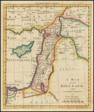
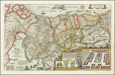
A flawless old color example of the modern map of the Holy Land, from the 2nd edition of the Ulm Ptolemy, the first atlas printed north of the Alps. The first and second editions can be differentiated most readily from the use of a golden brown for the water in the 2nd edition, rather than the dark blue used in the first edition. The map is oriented with East at the top and sshows the whole of Palestine on both sides of the Jordan, divided into the 12 tribes. The shore line runs from Sidon to Gaza. South of a fantasy Carmel Mountain there is a big island, called the Castle of the Pilgrims (Atlit), and a similar but smaller island, north of Jaffa, called Assur. The Carmel Mountain is misshapen. The Jordan River in its wide meanderings is shown in a thin line. The map is based upon a modern map by Petrus Vesconte, published in manuscript form by Marino Sanuto, ca. 1320, and updated by Donnus Nicholaus Germanaus in 1482. The map includes several notable improvements in the original Sanuto model, which are described in Nebenzahl. Germanus first issued the maps in manuscript versions of the Ptolemy Atlas, issued in 1466 and 1474 and later in the printed editions of Rome (1478) and Ulm (1482 and 1486). They are considered the first modern maps of the Holy Land and landmarks in the history of the printed maps of the Holy Land. An essential map for Holy Land collectors. This example is in exceptional condition, with wide margins. No appearances in dealer catalogues since 1988.
Claudius Ptolemy (fl. AD 127-145) was an ancient geographer, astronomer, and mathematician. He is known today through translations and transcriptions of his work, but little is known about his life besides his residence in Alexandria.
Several of his works are still known today, although they have passed through several alterations and languages over the centuries. The Almagest, in thirteen books, discusses astronomy. It is in the Almagest that Ptolemy postulates his geocentric universe. His geometric ideas are contained in the Analemma, and his optical ideas were presented in five books known as the Optica.
His geographic and cartographic work was immensely influential. In the Planisphaerium, Ptolemy discusses the stereographic projection. Perhaps his best-known work is his Geographia, in eight books. However, Ptolemy’s ideas had been absent from western European intellectual history for roughly a thousand years, although Arab scholars interacted with his ideas from the ninth century onward.
In 1295, a Greek monk found a copy of Geographia in Constantinople; the emperor ordered a copy made and the Greek text began to circulate in eastern Europe. In 1393, a Byzantine diplomat brought a copy of the Geographia to Italy, where it was translated into Latin in 1406 and called the Cosmographia. The manuscript maps were first recorded in 1415. These manuscripts, of which there are over eighty extant today, are the descendants of Ptolemy’s work and a now-lost atlas consisting of a world map and 26 regional maps.
When Ptolemy’s work was re-introduced to Western scholarship, it proved radically influential for the understanding and appearance of maps. Ptolemy employs the concept of a graticule, uses latitude and longitude, and orients his maps to the north—concepts we take for granted today. The Geographia’s text is concerned with three main issues with regard to geography: the size and shape of the earth; map projection, i.e. how to represent the world’s curve proportionally on a plane surface; and the corruption of spatial data as it transfers from source to source. The text also contains instructions as to how to map the world on a globe or a plane surface, complete with the only set of geographic coordinates (8000 toponyms, 6400 with coordinates) to survive from the classical world.
![[Cyprus, Holy Land & Medina]](https://storage.googleapis.com/raremaps/img/small/87154.jpg)