


|
||

|

|
|

|
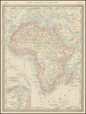
Late-19th-century map of Africa, focusing on German colonial endeavors on the continent following the Berlin Conference.
The map denotes other colonial interests as well, including those of the European powers and the Ottoman Empire.
Includes a number of inset maps, including:
- Lüderitz-Land (Der Südliche Theil von Deutsch-Südwestafrika) [Lüderitz-Land (The southern part of German South West Africa)]
- Das Kamerun-Gebiet [The Cameroon area]
- Togo-Gebiet (Sklavenküste.) [Togo area (Slave Coast)]
- Saxony
- German East Africa
- Germany
The insets of Germany and German regions are for the purpose of underlining the relative scale of Africa and the African colonies when compared with areas of land with which the German viewer would be more familiar. This no doubt reinforced the idea that the colonies were valuable and vital to Germany's future growth and international power, a preoccupation which lasted well into the 20th century.
The map was No. 43 of Carl Flemming's Generalkarte series. It was published with material updates through the 1880s, '90s, to 1900. The initial impetus for the map was no doubt the Berlin Conference of 1884-85.
Date is estimated.
![[Democratic Republic of the Congo] Congo Belge](https://storage.googleapis.com/raremaps/img/small/77991.jpg)
![Affrika třetj djl okrsslku zemského [Czech Language Edition]](https://storage.googleapis.com/raremaps/img/small/93470.jpg)