


|
||

|

|
|

|
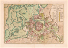
Vienna Before the Ringstrasse
Fine mid-18th-century map of Vienna, showing the layout of the city and its extensive and important fortifications. The Inner Stadt is still confined within its ancient city walls, while the city's suburbs are starting to expand further afield. This map was issued in 1837 in Vienna by the long-lived Artaria & Co. publishing house.
The map shows the city in a high level of detail, with all major streets named. Important buildings are labeled, and their location is indicated in a key to the side of the map, which is subdivided by neighborhood. The map extends to the Danube, the Donauinsel park, and the Josefstadt and Margareten neighborhoods. All major important buildings are shown, including the Hofburg Palace grounds.
Maps of Vienna in this era are prized as they provide a rare insight into the layout of the city as it was when it was a true cultural capital of Europe. The city was soon to be restructured, as discussed below, meaning that the city of Mozart, Salieri, Haydn, and their contemporaries was very different than that of Freud, Wagner, Adler, Zweig, and others who came later.
In the map, the city retains its early layout with two sets of ramparts, one around the outer perimeter of the city and one around the Innere Stadt. The two cities would not be joined politically or spatially until the mid-19th century when the ramparts were dismantled and replaced by the Ringstrasse. This ring road, attractive in its own right, is commonly used as a prime example of "historicism," or how historical context defines the use of space and vice versa. The early ramparts made for a crowded and separated city which led to its medieval characteristics, while the Ringstrasse allowed for a more connected and inclusive use of space.
![[Austrian Alps] Dachstein / Der Alt Welt Begriff, Besthende in 3 Haubt Theilen als Arica, Europa, Asia. Warinnen der Erste Meridian nach Frantzossicher art gezogen](https://storage.googleapis.com/raremaps/img/small/68924.jpg)
![(Austria) Charte der Österreichischen Monarchie, nach den letzten Friedensschlüssen berichtigt. [Map of the Austrian Monarchy, corrected according to the latest peace treaties.]](https://storage.googleapis.com/raremaps/img/small/102892.jpg)
![[ Innsbruck ] Oenipons Sive Enipontiis Vulgo Inspruck. . .](https://storage.googleapis.com/raremaps/img/small/89304.jpg)