|
||

|

|
|

|
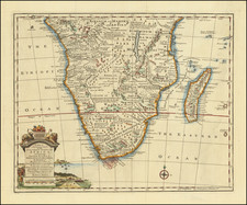
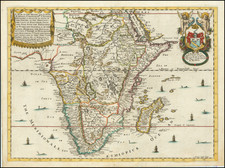
First State of Pieter van den Keere's Carte-a-Figures Masterwork
Rare first state of van den Keere's sought after decorative map of Africa, published in Amsterdam in 1614.
This first state of van den Keere's map of Africa is one of the earliest of the Carte-a-figures maps of Africa. While the copperplate would be acquired by Claes Jansz Visscher and re-issued in later decades, only this first state includes the title carouche with 2 cherubs. All later states incorporate a crocodile with an indigenous African on its back and remove the sailing ship west of the Cape of Good Hope.
The map relies upon the most recent advances in the cartographic depiction of Africa, particularly in the outline of the North African coast and Madagascar. Cape Horn is more prominent, with the addition of Saldanha and Cape Falco. The map also adopts the newest hydrography of the Congo River, drawn from the 1598 regional map of Central Africa by Filippo Pigafetta.
The map follows Ortelius’ model of the source of the Nile emanating from two large lakes in Central Africa, rejecting the model more recently used by Mercator, which had shown an extra southern branch of the Nile and smaller lakes. Like Mercator, however, the map includes a Nubian branch of the Nile. The Niger River configuration is also from Ortelius.
Beyond Ortelius, the coastal regions and toponyms are improved thanks to access to Linschoten’s Itinerario. The map reflects Portuguese sources as well, as it includes the Portuguese discoveries on the Upper Zambezi and their interactions with Monomotapa in Southeast Africa.
In the waters surrounding the continent are several sailing ships. They should be wary of the sea monsters that are also in the seas. Many islands dot the ocean, including São Tomé and Principe, which are noted for their sugar, and St. Helena, an important stop-over on the route to the East Indies.
Monomotapa
Th kingdom of Monomotapa is shown in the south. In the early fifteenth century, a prince of the Kingdom of Zimbabwe established his own seat of power called the Kingdom of Mutapa to the north. The kingdom expanded quickly, fed by the region’s gold reserves and trade connectivity.
The Portuguese heard of the empire, which reached its peak in 1480, when they rounded the Horn at the end of the fifteenth century and began trading along the coasts of southern Africa. The Portuguese traders transliterated the word for ruler, Mwenemutapa, to Monomotapa, which was then used to describe the region on maps.
In the 1560s, the Portuguese Crown entered into direct relations with Mutapa; in 1569, King Sebastian gave a coat arms to the Mwenemutapa, the first grant of arms to a native southern African. However, this interaction was not characteristic of Portuguese-Mutapa relations, which were often combative as the Portuguese sought to take over the local gold reserves. These gold reserves were connected in European minds to the gold mines of King Solomon, ensuring Monomotapa an enduring place in the European geographic imagination.
States of the Map and Rarity
Schilder records five examples of the first state: University of Berlin State Library, Regensburg Library, Library of Congress and 2 in a private French collection.
The cartography of Africa to ca. 1570
Medieval mapping of the African continent was tied to the Christian worldview. Traditionally, the known world of Antiquity, which included the north of Africa, Asia, and Europe, was arranged symbolically in what is known as a T-O map. Such world images were common in Medieval manuscripts and they show the three landmasses in a T shape with an O, the ocean, surrounding them. The T-O maps are east-oriented—Paradise and Eden were supposedly located to the east—and some have Jerusalem at their center. Europe is in the bottom left corner and Africa the bottom right.
Over the course of the Medieval period, mappaemundi on the T-O model were increasingly stuffed with new place names and features, particularly those mentioned in the popular travel narratives of Marco Polo and Sir John Mandeville.
From roughly 1200, portolan charts showed increasing portions of the African coast. Meant for maritime navigation, these charts contained little to no information about the interior of the continent. They did, however, reflect the advancement of European, particularly Portuguese ships south along on the west coast of Africa. The culmination of these voyages was in 1498, when Vasco da Gama rounded the Cape of Good Hope and reached the Indian subcontinent.
Da Gama’s forging of an all-water route to India was particularly illuminating when compared with the prevailing geographic theories of the day, which were dominated by work of the second-century AD Alexandrian scholar, Claudius Ptolemy. Ptolemy postulated in his famous work, Geographia, that the Indian Ocean was enclosed by land which stretched from the south of Africa to southeast Asia. Early modern scholars were already questioning Ptolemy, however, even before da Gama reached India. For example, the Fra Mauro map has a peninsular southern Africa with a waterway flowing around it.
Early printed editions of Ptolemy—the first with maps was printed in 1477 in Bologna—would increasingly include tabula nova, or new maps, which supplemented Ptolemy’s ideas with more modern observations. The first edition to include the Portuguese discoveries in Africa was the Rome edition of 1508. The first surviving printed map to include the discoveries was the earlier Contarini-Roselli world map of 1506, the only surviving example of which is at the British Library.
Martin Waldseemüller’s 1507 world map, the sole example of which is now at the Library of Congress, also shows the revised version of the continent. Additionally, Waldseemüller included the new discoveries in his Africa maps for an edition of Ptolemy published in 1513. The first modern map of the entire African continent was in Sebastian Münster’s edition of the Geographia published in 1540 (and his Cosmographia of 1544). After Münster, Ortelius’ 1570 map was the first widely-distributed map of the continent and it would popularize the ideas of Giacomo Gastaldi, his main source. It also inspired other maps, like the second map of Africa included in later editions of the Cosmographia.
Gastaldi lived in Venice and had collaborated with Ramusio on his famous travel collection, which gave Gastaldi access to the latest geographic knowledge. In his important, yet not widely distributed, 1564 map of Africa, Gastaldi corrected the southwest coast, which was typically sloped too steeply. He also introduced a novel depiction of the sources of Africa’s rivers. Finally, he drastically increased the number of place names included: 655 names along the coast and a whopping 1200 in the interior.
Ortelius and those who followed him retained many of these place names, although he shifted some to new locations. In some cases, as with the names of lakes, he largely used his own names. He also scaled down the level of ornamentation and decoration drastically as compared to the 1564 map. Ortelius also corrected Gastaldi by narrowing the point of the Cape of Good Hope and reduced the extension of the continent to the east. These adjustments made Ortelius’ map far closer to the actual east-west, north-south size of the continent; it was the most accurate map of Africa to date.
The cartography of Central Africa and the source of the Nile
The innovative depiction of the African river systems in Gastaldi and Ortelius are notable for their divergence from previous models and for their importance as a model for future mapmakers. Typically, mapmakers thought the Nile River rose from twin lakes south of the equator, which were near the Mountains of the Moon. Streams from the mountains fed the lakes. Ptolemy describes such a lakes-and -mountains layout in his works, although the precise identification of the Mountains of the Moon may have been a fourth century addition to his text.
Sixteenth century mapmakers, including Waldseemüller and Münster, chose to follow the Ptolemaic model. This was typical of cartographers at the time, who had abandoned Ptolemy’s coastlines in favor of the more recent Portuguese outlines yet who also clung to Ptolemaic place names for the interior of Africa well into the nineteenth century.
Gastaldi, most likely thanks to sources he read via Ramusio, chose to abandon the Mountains of the Moon entirely. Instead, he drew a massive central lake from which flows the Nile, Zaire (Congo), Cuama (Zambezi), and Spirito Sancto (Limpopo) Rivers. To the east is another, smaller lake at roughly the same latitude, which also feeds part of the Nile. Therefore, Gastaldi created an entirely different view of the interior of Central Africa, while still embracing Ptolemy’s twin lakes theory.
![[Wall Map of Africa] L'Afrique Divisee en ses Principales Parties et ses Isles Tire des Relations les plus Recentes . . . 1782](https://storage.googleapis.com/raremaps/img/small/91459.jpg)