


|
||

|

|
|

|
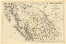
Historically important map of British Columbia showing the area after the province entered the Canadian Confederation. The map shows the proposed Canadian Pacific Railway, a project undertaken in return for the entry of British Columbia into the Confederation.
The map is particularly notable for showing proposed routes that could be taken by the railway. One "definite" line is shown, as far west as the Fraser River, and then the line bifurcates into several possible lines, all terminating far to the north of Vancouver. However, this "definite" route, which cross the Rocky Mountains at the relatively low Yellow Head Pass (also named Leather Pass on the map), would eventually be scrapped in favor of the more southerly Kicking Horse Pass. The Yellowhead Pass would later be used for the Canadian Grand Trunk Railway, built between 1910 and 1913.
The map is highly detailed and shows Vancouver, Vancouver Island, Puget Sound, the San Juan Islands, all of British Columbia, and some of Alberta. Topography is indicated, and many lakes and rivers are named.
On July 20, 1871, British Columbia became the sixth province to join Canada. In return for entering the Confederation, Canada absorbed B.C.'s massive debt, and promised to build a railway from Montreal to the Pacific Coast within 10 years, ending a period in which the residents also debated joining the United States or remaining a British Colony. The last spike of the Canadian Pacific Railway was driven in Craigellachie in 1886. The completion of the CPR brought about a period of explosive growth in British Columbia that soon saw the province become Canada's third-most-populous province.
![[Alaska to San Diego and San Qunitin, British Columbia] A Chart Shewing Part of the Coast of N.W. America, with the Tracks of His Majesty's Sloop Discovery and Armed Tender Chatham . . . (First Modern Map of the West Coast of North America)](https://storage.googleapis.com/raremaps/img/small/102067.jpg)