


|
||

|

|
|

|
Rare Second Edition of "Perhaps the Earliest Large Scale Separately Printed Sectional Map of the Territory" (Eberstadt)
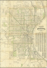
Rare, early Milwaukee-published map of Wisconsin by Increase A. Lapham, the most important mapmaker in Wisconsin, published by Hale & Chapman. The map represents a fantastic triumph of the early cartography of the territory and shows the extent of the early township surveying in the part of the territory closest to Lake Michigan. This is the 1848 edition of the map, which was first issued in 1846.
This appears to be the first printed state map that Lapham issued, as suggested by Rumsey. Lapham was an incredibly important figure in the early territory who is considered by the Wisconsin Historical Society to be Wisconsin's "first scientist and one of its foremost citizens." He had become the chief city engineer of Milwaukee starting in 1836. Lapham's earliest map was his 1845 City of Milwaukee, with this map following shortly after.
The map shows cities, including a developed Green Bay and Milwaukee. Counties are also named. Other details include copper and lead mines, especially around Mineral Point.
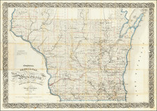
The 1848 edition of this map can be identified by the "8" in the date that has been modified in the matrix from a "6". This edition of the map now names Adams County, and extends the surveyed region into Crawford territory.
Rarity
OCLC lists two examples of this edition of the work, at Yale and at the Wisconsin Historical Society Archives.
RBH records only two examples (in 1997 and 2011) of any edition having sold since the Streeter copy in 1967.

![[ The Old Northwest Territory ] Il Paese De Selvaggi Outagamiani, Mascoutensi Illinesi E parte Delle VI Naxioni](https://storage.googleapis.com/raremaps/img/small/75927.jpg)