This item has been sold, but you can enter your email address to be notified if another example becomes available.


|
||

|

|
|

|
Stock# 8064
Description
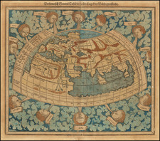
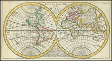
Interesting early map of the World, which first appeared in Rosaccio's 1598 edition of Ptolemy's Geographia and was later re-issued by Lasor a Varea in their Universus Terrarum Orbis Scriptorum, published in Padua in 1713.
The map is based upon Rumold Mercator's map of 1587, but with parallel latitudinals. The projection of North America is similar to the Zaltieri/Lafreri maps of North America, with a terrific projection of NW Coast of America. Large Terra Australis. Fascinating depictions of the NW Passage, NE Passage and Asia. Curious shape for Florida. Predates the explorations of Le Maire & Schouten, which rounded Cape Horn and established that there was open water south of Tierra del Fuego and the Straits of Magellan.
Condition Description
Nice example, with a bit of extra printer's ink. Strong impression.
Reference
Shirley 217.
![[Spectacular Set of Wall Maps of the Continents Dedicated to King Charles II of England, &c.]](https://storage.googleapis.com/raremaps/img/small/93614.jpg)