|
||

|

|
|

|
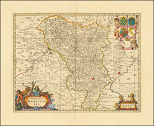
Beautiful example of Jansson's map of Lancashire in northwestern England, first published in the middle of the seventeenth century and here reissued by Valk and Schenk circa 1690. The map preserves a fine and detailed look at the region that stretches from the southern Lakes and Lancaster in the north to the mouth of the Mersey River in the south.
The map is highly informative and shows a range of features including coastal marshes, walled gardens, lakes, mountains, and forests. In the northeast, Pendle Hill and Longridge Hill stand tall above the surrounding area. Manchester is shown, although it has not yet grown to its present-day importance and only Lancaster is highlighted. Other cities shown include Bolton and Blackburn.
The map is highly decorative in the style of 17th-century Dutch maps, with a compass rose, two ships at sea, and three ornate cartouches.
![[London to Sheppey Island / Great Yarmouthand environs] Afteekening van de Rivier van London of River Thames / Afteekening van de Tarmouthse Banken geleegen voor Iarmouth Aan de Oost](https://storage.googleapis.com/raremaps/img/small/85128.jpg)