|
||

|

|
|

|
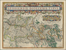
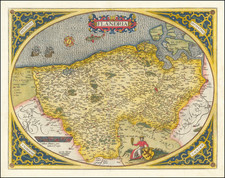
Gorgeous example of Pieter Van Den Keere (Petrus Kaerius) map of the Hainault region of Belgium and a portion of the Nord department of modern France, with a fine inset view of Mons and Valenciennes, from Van Den Keere's Germania Inferior id est, XVII Provinciarum ejus Novae et Exactae Tabulae Geographicae, first printed in Amsterdam in 1617.
Van Den Keere's atlas of the Low Countries is one of the landmark regional atlases of the early 17th Century, with the maps engraved by Van Den Keere, who would go on to do significant work for John Speed and a number of other mapmakers in the first part of the 17th century. The map shows the area around Antwerp in exceptional detail, showcasing Van Den Keere's engraving skills.
The map would later be re-issued by Claes Jansson Visscher in 1624 and after, with the date and credit below the view of Antwerp changed accordingly.
![[ Siege of Ostend ] Oostende](https://storage.googleapis.com/raremaps/img/small/96446.jpg)