
The item illustrated and described below is sold, but we
have another example in stock. To view the example which
is currently being offered for sale, click the
"View Details" button below.


|
||

|

|
|

|
Stock# 80586
Description
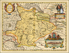
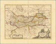
A fine early map of the part of Gelderland, in the region then controlled by the Counts of Zutphen, which appeared in Petrus Kaerius's (Peter Van der Keere) Germaniae Inferior id est, XVII Provinciarum ejus novae et exactae Tabulae Geographicae, first published in Amsterdam in 1617.
Van der Keere's atlas was the first separately published atlas of the Low Countries.
The map includes a view of the city of Zutphen, a coat of arms and costumes showing typical regional dress.
![[Zeeland] De Cust van Zeelandt, Begrypende in sich de gaten, als vande Wielingen, ter veere, Ziericzee, Brouwershaven, Goeree, en de Maes.](https://storage.googleapis.com/raremaps/img/small/83992.jpg)