|
||

|

|
|

|
Manuscript Plat Map of Georgia Lands in Liberty County
With the Original Wax and Paper Seal of Georgia Designed by Daniel Sturges - who has also signed the document
An original Georgia land warrant or grant for 200 acres in Liberty County. The main grant document, which has a decorative printed border, and still has the original paper-encased wax seal, includes a manuscript plat map, measuring approximately 5 x 7 inches, illustrating the location of the 200 acres.
The text of the document, with manuscript content here transcribed within brackets, reads largely as follows:
[Entd. Jas. Bozeman, Compr; Genl.]
Georgia, [Liberty County]. Warrant dated [1st January 1816] and surveyed the [1st November 1816] for [William Evans] who resides in this State, a tract of [Two Hundred] acres of land bounded [North by James Elders land; N.W. by land of the Est:e of Jas: Smart; S.E. by Knights land, and on all other sides by vacant vacant land.] Advertised [18th Novr. 1816. Surv:d by Rob: Hendry, CS, Dan:l Sturges Sur: Genl.]
The attached printed document on a slightly smaller sheet reads as follows:
State of Georgia. By his Honor William Rabun, President and Commander in Chief of the Army and Navy of this State, and of the Militia thereof ... Know ye, that in pursuance of the Act for opening the Land Office, and by virtue of the powers in me vested, I have given and granted, and by these presents, in the name and behalf of the said State, Do give and grant unto William Evans, his heirs and assigns forever, all that Tract of Land containing ... Acres ... lying and being in the County of Liberty in the said State; and butting and bounding North by James Elders Land. N.W. by land of the Est. of Jas. Smart. S.E. by Knights Land and on all other sides by Vacant Land.
The main document is signed by the following people:
- Daniel Sturges, Georgia Surveyor General (see below on his importance as a mapmaker)
- James Bozeman, Georgia Comptroller General
- Robert Hendry, surveyor
- George R. Clayton
- Will Johnson
- Elias Knight
The plat map
The manuscript plat map is quite detailed and indicates the relative location of various features, including lakes or ponds and the Riceboro Road. Riceboro was the county seat of Liberty County at the time. Also noted are stands of pine and cypress trees, and the names of neighboring landowners.
Scale of [20] chains to an inch.
The Mapmaker
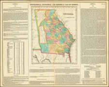
Daniel Sturges was a very important mapmaker in early Georgia. As Surveyor General he played an important role in various land development schemes coinciding with the settlement of Georgia in the early 19th-century. His 1818 Map of the State Georgia can be styled the Holy Grail of Georgia maps. It was a large and elaborate production that also showed adjoining parts of South Carolina. The map was notable as the first systematic survey of Georgia, being based on Sturges's wide experience surveying lands for private owners, such as in the present plat.
The Great Seal of the State of Georgia
The original wax and embossed paper seal attached to the present document was designed by Daniel Sturges, who has also signed the document as Surveyor General of Georgia. Sturges submitted his winning seal design in a competition held in 1799. On February 8, 1799 an act of the Georgia Legislature official adopted Sturges' design:
On the one side a view of the seashore with a ship bearing the flag of the United States, riding near a wharf, receiving aboard hogsheads of tobacco and bales of cotton, emblematic of the exports of this State; at a small distance a boat landing from the interior of the State with hogsheads etc., on board representing her internal traffic; in the back part of the same side, a man in the act of ploughing; and at a small distance a flock of sheep in different postures shaded by a flourishing tree, the motto on this side agriculture and commerce, 1799. That the other side contain three pillars supporting an arch, with the word Constitution, engraven within the same, emblematic of the Constitution supported by three departments of the government, viz.: the legislative, judicial and executive, the first pillar to have engraven on its base, wisdom; the second justice; and the third, moderation; on the right of the last pillar a man standing with a drawn sword, representing the aid of the military in defense of the Constitution; the motto, State of Georgia, 1799.
Originally the dates listed on the obverse and reverse of the seal were 1799 (as in the present example). The dates were changed to 1776 by the Georgia state legislature in 1914 to reflect the date of the signing of the Declaration of Independence.
Daniel Sturges is an important figure in early history of the state of Georgia.
Sturges was born in 1765 to the Reverend Daniel and Eleanor Sturges of Norborne Parrish, Virginia. The Sturges family migrated to South Carolina about 1789 and then to Georgia in 1790.
During the 1790s, the younger Daniel served as Deputy Surveyor General of the state and on January 26, 1797 was elected Surveyor General of Georgia. He served in this capacity for six terms until 1809 and was reelected by the Senate again in 1817, serving until his death in 1823 when his son Benjamin Hicks Sturges succeeded to complete his father’s term.
Besides submitting the winning drawing for Georgia’s Coat of Arms and Great Seal, Sturges also devoted twenty years to compiling the first detailed published map of the entire state.
Sturges administered the first four of Georgia’s six land lotteries, in 1805, 1807, 1820, and 1821, so he had a significant influence on the development of the state’s land policies. Sturges died at Columbia, South Carolina on September 17, 1823 (Cadle, 1991).

![Neueste Karte von Georgia mit seinen Strassen, Eisenbahnen und Entfernungen 1845. [Latest Map of Georgia with its Roads, Railways, and Distances 1845.]](https://storage.googleapis.com/raremaps/img/small/94441.jpg)