


|
||

|

|
|

|
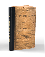
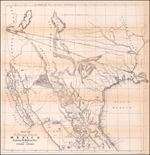
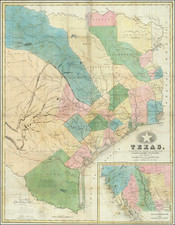
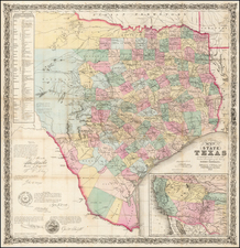
A Seminal Early Map of Texas as a Republic, with the first edition of "the First General Guide to Texas" (Streeter)
Hunt & Randel's map of the Republic of Texas is one of the earliest large maps of the Republic and certainly one of the most important and influential maps of the Republic period. Published to accompany Hunt & Randel's Guide to the Republic of Texas, the work is of seminal importance, being called by Thomas W. Streeter the "first general guide to Texas."
This is the 1839 first edition of a cornerstone map and book for the Republic of Texas. As noted by Streeter, "the map is important.... It shows, probably for the first time, the newly laid out town of Austin on the north bank of the Colorado," and almost certainly the earliest printed map of Texas based upon actual surveys.
In the lower left corner the map is a testimonial to the accuracy of the map stating:
We the undersigned have inspected the above map and give it our approval as being a compilation from the best and most recent authorities”
James Webb Secy. of State.
John Woodward Consul Genl. of Texas, N. York.
Francis Moore Jr Editor Telegraph, Houston.
Below that is the Certification John P. Borden, Commissioner of the General Land Office of the Republic of Texas, dated Apr. 25, 1839, which certifies that the compiler of the map was given access to the General Land Office records in order to compile the map.
Streeter (1348) says of the map and guide:
The contents of this Guide, the first general guide to Texas, are pretty well stated in its title. It must have been a useful book for intending settlers, and its contemporary account of existing conditions makes it a valuable book now. The map is important.
Unlike several Texas maps...such as the series by Hooker first issued in 1833, by Burr in 1833, and by J.H. Young in 1835, all of which showed the colonization grants in far western Texas and were on a small scale, this shows Texas only to a little west of the 101st meridian, or less than 150 miles west of San Antonio. In this respect it follows the Austin maps...that go only to a little west of the 102nd meridian and have the large scale of 24 miles to the inch. In the prefatory remarks to this Hunt and Randel Guide, it is stated that though the map is necessarily imperfect in some details, it is based from the coast to the San Antonio Road on existing surveys, and that the principal rivers are accurately laid down for more than 100 miles above that road. The claim is made that “this map is the only one which makes any pretentions to being based on accurate surveys.”
The 1839 map shows in colors thirty-one counties with their boundaries clearly defined, the latest being Harrison, which was organized under an act of the Third Congress dated January 28, 1839.... It shows, probably for the first time, the newly laid-out town of Austin on the north bank of the Colorado.... The inset map is most interesting, showing as it does “Upper California” and “Lower California” from the 23d to the 42d parallels, with many place names and the Timpanogos and Buenaventura rivers running to the sea, and with the north boundary of the Mexican province of Sonora at about the 29th parallel.
Hunt & Randel wrote the book in Houston, Texas, which is attested to on the title page.
Among other things, the map was offered as evidence in an 1896 United States Supreme Court case, where it is cited, along with the the Austin, Disturnell and Pressler maps, in the dispute as to whether Greer County was part of Texas.
Rarity
We note only 3 examples of the book and map at auction since 2000.
This is the second example of the map we have offered for sale in over 25 years.
![[Texas & Oklahoma] Amer. Sep. No. 55. Partie Des Etats-Unis](https://storage.googleapis.com/raremaps/img/small/93537.jpg)