


|
||

|

|
|

|
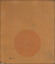
Fine comparative depiction of the relative heights of the mountains of the world, published in Berlin in 1806. The map represents an early and uncommon representation of this thematic mapping which would become wildly popular in the latter part of the century. This appears to be a rare separately published example of a chart that would later appear in a scarce and desirable 1811 treatise on the heights of mountains in the Solar System.
This plate shows the elevations of over one hundred mountains across all of the continents. The highest mountain shown is Chimborazo in Ecuador, which had recently been climbed by Humboldt, giving it a height of approximately 3500 "toises." These are compared to the highest elevations reached by hot air balloons, including Joseph Louis Gay-Lussac and Jean Baptiste Biot's trip above 7000 meters. Heights of the Pyramids and the Tower of Munster are provided for comparison.
This map was produced by the Swiss engraver Christian von Mechel, and based on his 1806-published Table des Hauteurs principales de notre planete. Given the large margins, thick paper, and the fact that it was never folded, this appears to be a separately published, earlier state of this chart. The chart is most recognized for its later appearance in the important 1811 Allgemeine Darstellung der Oberflachen der Weltkorper unseres Sonnengebietes. . ., by the German astronomer Gelpke. This book discussed the comparative heights of mountains on earth and in the Solar System.
The map is fantastically colored in full, and presents a host of fascinating information. The decor is substantially more subdued and perhaps more tasteful than later examples of this type of mapping.
![Tableau general des courants atmospheriques et oceaniques [General map of atmospheric and ocean currents]](https://storage.googleapis.com/raremaps/img/small/85734.jpg)
![[Tampa] Perfecto Garcia & Bros. Clear Havana Cigars](https://storage.googleapis.com/raremaps/img/small/87436.jpg)
![(Horse Diving) [Original photograph of Sonora Carver on her horse Red Lips in mid-air diving off a platform]](https://storage.googleapis.com/raremaps/img/small/96798.jpg)