|
||

|

|
|

|
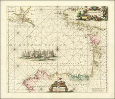
Rare broadside map showing the Battle of La Rochelle in 1573, which seems to have been engraved in France by an unknown engraver.
During the French Wars of Religion La Rochelle had become a center of Huguenot support, and was besieged by troops loyal to the Catholic Duke of Anjou. The siege was lifted in the year the map was made and La Rochelle became one of the few cities in France where Protestants were allowed to worship.
The map clearly shows the formidable fortifications of La Rochelle, full of thick and angled walls designed to deflect cannon fire and force attacking troops into narrow spaces easy to attack from the walls.
Rarity
We locate 2 other examples on line, each of which is a variant, with different text in the image. The example at the Bibiotheque National de France (BNF) example also seems ot have a name below the title, which is unfortunately illegible.
BNF Copy: https://gallica.bnf.fr/ark:/12148/btv1b8400698v
The University of Dillingen also holds a copy, bound into a Lafreri Atlas. https://www.bavarikon.de/object/bav:SBD-HSS-00000BSB00106477?view=meta&lang=de
Siege of La Rochelle
The siege of La Rochelle of 1572–1573 was a massive military assault on the Huguenot city of La Rochelle by Catholic troops during the fourth phase of the French Wars of Religion, following the August 1572 St. Bartholomew's Day massacre. The conflict began in November 1572 when inhabitants of the city refused to receive Armand de Gontaut, Baron de Biron, as royal governor.
Beginning on February 11, 1573, the siege was led by the Duke of Anjou (the future Henry III). Political considerations following the duke's election to the throne of Poland in May 1573 resulted in negotiations, culminating on June 24, 1573, that lifted the siege on July 6, 1573. The Edict of Boulogne signed shortly thereafter brought an end to this phase of the civil war.
![[Mossaic]. Pourtraict de la ville de Moissac](https://storage.googleapis.com/raremaps/img/small/73919.jpg)