|
||

|

|
|

|
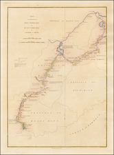
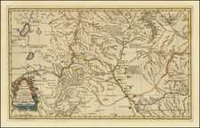
Large and finely executed manuscript map of the Sichuan Province, drawn by a Jesuit Missionary in the mid-19th Century.
The map seems to divide Sichuan into 3 sub-regions, likely sub-regions reflecting the location and governance of local missions. It provides an a detailed schematic look at the local villages, roads, rivers and mountains in the region.
The map would have been drawn during the Jesuit Missionary period following the first Opium War, which is typically referred to as the Second Mission (1842-1949), the First Mission being 1552-1773).
The map comes from a large collection of manuscript maps de-accessioned by a German Jesuit library sometime in the 1980s. The library stamp can be seen at the lower right and the Library mark at the lower right. The collection was acquired by a well-known German map dealer and over the years we have seen hundreds of maps from all parts of the world with same markings.
A fascinating artifact of the Jesuit time in China in the 19th Century and well worthy of further study.