


|
||

|

|
|

|
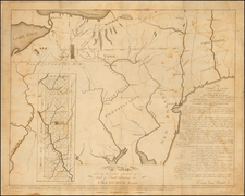
1870 Facsimile of "The Finest Printed Cartographic Document Relating to North America to be published to date" (Burden).
Charles Warner's 1870 lithographed reproduction of the extraordinary Holme map of Pennsylvania, a "monumental work" and "the greatest of the early American maps." The map is one of exceeding importance to American cartography and the history of Pennsylvania, being the only example of a 17th century British North American colony to such an extent.
The map shows the western bank of the Delaware River between what is now Wilmington to the south and Trenton to the north. Townships and the plots of individual proprietors are shown and labeled, preserving an unparalleled level of detail regarding the early colonization of the region. In the upper right, an inset shows Philadelphia, with its town hall, High Street, Broad Street, individual plots, the Schuylkill River and the Delaware River all depicted.
The History of the Holme Map
In 1681, William Penn was granted sole proprietorship to more than forty-five thousand square miles in a region that he named Pennsylvania. Through vigorous promotion more than a half-million acres were sold in the first year alone. Because each tract had to be laid out before it could be developed, Penn appointed Thomas Holme surveyor general of the colony in April 1682. Holme immediately began to survey the land and to lay out the future city of Philadelphia. A plan titled A Portraiture of the City of Philadelphia was published in 1683. Penn then pressured Holme to produce a general map of the colony complaining from London that "we want a map to the degree that I am ashamed here … all cry out, where is your map, what no map of the settlements!"
The completed manuscript was on its way to Penn in London by May 1687 and the finished map was advertised in January 1688. It illustrates the "improved", or settled area of the province, along the western bank of the Delaware River, a tract of approximately fifty-five miles in length and thirty-three miles in width. On a scale of one mile to one inch, it locates the holdings of 670 settlers and was the only map of any English colony to give such a detailed account of settlement. Holme's 1683 plan of Philadelphia, the first published for any English American city, was included in reduced form as an inset in the upper right corner. The map's prolific size insured its rarity over time. A reduced version was published by Philip Lea around 1690.
This map is based on an example of the second state of the Holme Map, where the Neshaminy Creek in the right of the map crosses the words "Bucks County" between the K and the S and the C and the O.
Rarity
The original Holme map is virtually unobtainable; commanding prices in excess of $300,000. For most collectors is the only realistically obtainable edition of the map, and even this edition is rare, with the present example being the second that we have seen in thirty years in business.
![[ Virginia / Maryland / Chesapeake Region ] Pas Kaart van de Zee Kusten van Virginia Tusschen C. Henry ent Hooge Land van Renslaars Hoek. . .](https://storage.googleapis.com/raremaps/img/small/47255.jpg)
![[4 Colonial and 18th Century Manuscript Surveys on the Delaware River]](https://storage.googleapis.com/raremaps/img/small/89416.jpg)
![1794 Land Survey Signed by Alexander McDowell D[eputy] S[urveyor]](https://storage.googleapis.com/raremaps/img/small/101014.jpg)