


|
||

|

|
|

|
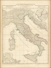
Rare map of Italy, first published by Melchior Tavernier and later re-issued with the new title pasted over the old title by a Nicolas Sanson.
The original title of the map was Italia Antiqua Cum Insulis Sicilia, Sardinia & Corsica . . .
This unusual map depicts Italy at the time of the Romans and was intended to be hand colored to depict the Roman Roads. However, this seems to be a proof state, lacking the roads, with a grid and guidelines from the original edition of the map still showing--likely an early Sanson revision to the map, before it was finalized.
While most of the grid lines were removed on the final draft, some can still be seen (see the BNF copy, top right corner for the lines running down from 44 and across from 45 and 44 at the upper right part of the map: gallica.bnf.fr/ark:/12148/btv1b5963854j
Melchior Tavernier was an engraver and printer to the King of France and would also serve as the distributor in France of the cartographic works of Hondius, Jansson and Blaeu. He was the principal mapmaker in France between the eras of Jean Le Clerc and Nicolas Sanson. His business would pass on to Pierre Mariette, who in turn would partner with Nicolas Sanson. Tavernier, would later publish some of Christophe Tassin maps in his own atlas production ( Theatre Geographique 1634, 1637, 1638, 1643). A number of Sanson's earliest maps include Tavernier's imprint.
Melchior Tavernier was a member of a large family involved in the publishing trade in Paris in the early years of the seventeenth century. Early in his career, he apparently collaborated with Henricus Hondius, as at least one of his early maps references Tavernier as the seller of a map engraved in Amsterdam, by Hondius. He is probably best known for his publication of a map of the Post Roads of France, which was copied many times until the end of the century. He also issued an atlas under the same title as J. le Clerc's Theatre Geographique, using many of Le Clerc's maps, but incorporating others from different sources. He published composite atlases and also published works for other cartographers, including N. Sanson, N. Tassin, and P. Bertius. He is not to be confused with his nephew of the same name (1594-1665), who also engraved maps for Nicolas Sanson.
![[Composite Lafreri-style Atlas of Battle Plans and Fortifications]](https://storage.googleapis.com/raremaps/img/small/92702.jpg)
![[ Florence and Genoa ] Genua Ligurum domina . . . [and] Florentia urbs est Insignis Hetruariae, olim Fluentia dicta . . . (Genoa & Florence)](https://storage.googleapis.com/raremaps/img/small/67437.jpg)
![L'Italie divisee en ses differens Etats… [2 sheet map]](https://storage.googleapis.com/raremaps/img/small/66173.jpg)