


|
||

|

|
|

|
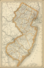
First Printed Map of the State of New Jersey
Nice early example of the first edition Mathew Carey's map of New Jersey, published in Carey's American Atlas in 1795.
The map provides topographical information and locates counties, the division between East and West Jersey, and many roads and towns. Shipman's Tvn is shown near Phillipsburg, with a road leading from Hiccory Tvn, to Bunnel's Tvn. The map was first advertised by Carey in 1794, but no separate issues have been located. Snyder notes that the map was an improvement over Faden's map in accuracy, showing counties and roads
This is the first state of the map, distinguishable from the second state by the lack of the #32 in the upper right corner, which appears in later states.
The present example includes two names below Shrewsbury, one of which is "McKnight's", in the area of the modern town of Long Branch, a reference to McKnight's Hotel. The property was first utilized by a British Officer, Colonel White or Ebenezer Wardell, as a summer seaside residence prior to the American Revolution. In 1788, Elliston Perot of Philadelphia persuaded the caretaker to allow him to occupy the property with his family and shortly thereafter, a Mr. McKnight acquired the property and made additions, creating a hotel. The hotel was purchased in 1820 by William Renshaw and sold to James Green in 1837, who built the Bath Hotel, which burned in 1867. The property thereafter became the site of the Scarboro Hotel.
Carey's American Atlas was the first atlas published in the United States, compiling a number of excellent maps from indigenous sources in the first compilation of American maps. This map was engraved by Samuel Lewis.
An essential map for New Jersey collectors.
![Map [No. 2] of Property owned by the Rutherford Heights Association To Be Sold At Auction, May 16, 1871](https://storage.googleapis.com/raremaps/img/small/71908.jpg)
![[ Cape Hatteras to New York City ] The Coast of the United States of North America; from New York to St. Augustine: Drawn and regulated according to the latest Surveys and Astronomical Observations By Edmund Blunt. Additions to 1839 & 1840](https://storage.googleapis.com/raremaps/img/small/84684.jpg)