


|
||

|

|
|

|
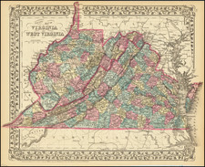
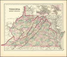
The Last of the VMI / Maury Maps of Virginia
Rare map of Virginia, published by James Waddell, in connection with the rare 1878 supplement to Mathew Fontaine Maury's Physical Survey of Virginia, published in Richmond in 1878.
The map gives a meticulous overview of Virginia, including Court Houses, Churches, Mineral Springs, Railroads and Canals (existing and proposed), Bridges, Ferries, Mills and Fords. This is the last of the Virginia maps prepared under the direction of Matthew Fontaine Maury (1806-1873), the legendary Virginia astronomer, historian, oceanographer, meteorologist, cartographer, author, geologist, educator, and naval officer, who at the time was in his final years at Virginia Military Institute.
Waddell's map is on a similar scale to the final (1868) edition of the Bucholtz-Ludwig Map, which was first issued in 1858. As can be seen from the list of sources, Waddell has added information from a number of new sources, including Coast Survey maps, Post Route maps of Virginia compiled by Postmaster General Alexander Randall in 1869, 1868 Ordinance Survey maps prepared by Henry James in 1868, George Finch's map of Mecklenberg (1870), John Hotchkiss's map of Augusta (1870) and a number of other maps and sources noted in the list at the left of the map.
The most notable correction is the removal of the erroneous state border that locates Alleghany, Bath and Highland counties in West Virginia. The key includes populations of cities, towns, and townships as of 1870.
Unlike prior editions of the map, no effort is made to delineate counties or other details in West Virginia, other than its basic hydrographic features.
Rarity
The map is apparently quite rare on the market. This is the first example have offered for sale.

![[ Virginia Natives ] Fictilium Vasorum In Quibus Cibum Coquunt Forma XV [Their Seething of Their Meat in Earthen Pots]](https://storage.googleapis.com/raremaps/img/small/98700.jpg)
![[ Yorktown ] Plan of the Siege of York Town in Virginia . . .](https://storage.googleapis.com/raremaps/img/small/102061.jpg)