This item has been sold, but you can enter your email address to be notified if another example becomes available.


|
||

|

|
|

|
Stock# 8036
Description
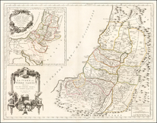
Detailed regional map of the Holy Land and region to the South. Shows early towns, rivers, lakes, islands, mountains, early roads and a host of other details. Decorative piano key border. Inset plans of Jerusalem at the time of Christ and the Israeli Desert Camp around the Tabernacle, by tribes.
![(Israel) Tabula Moderna Terre Sancte [Modern Map of the Holy Land]](https://storage.googleapis.com/raremaps/img/small/101884.jpg)
![Turkey in Asia [with Cyprus]](https://storage.googleapis.com/raremaps/img/small/59273.jpg)