|
||

|

|
|

|
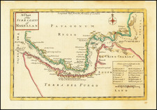
Shows Darwin's expeditions during the second voyage of the Beagle.
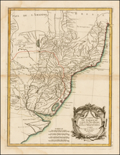
A highly detailed map of Argentina, Chile, Uruguay and Paraguay, with an inset of Patagonia, published by John Arrowsmith, London's leading mid-19th-century map maker. The map is colored by regions and shows more detail than any contemporary commercial atlas map of the region. A truly impressive and highly detailed map.
Many of these countries shown have borders almost unrecognizable when compared to the present. Bolivia reaches the coast in the Atacama region, while Peru controls the Tarapaca Province. Chile, despite being the most stable state in the region, is stumpy and extends neither far to the north or south. This would be resolved by the War of the Pacific and the Boundary Treaty of 1881, leading to the elongated shape we see today. Uruguay is the only country without major changes, though the Lake Merin area is shown as unclaimed. The detail on the map is, as previously mentioned, remarkable. All major features known at the time are shown, and many provinces named. Includes extensive and interesting notes, from translations to information on the passibility of rivers to routes of expeditions through these countries. The map shows Darwin's expeditions during the second voyage of the Beagle.
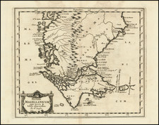
The inset map shows Patagonia, Tierra del Fuego, and the Falklands. Less detailed than the main map due to a lack of knowledge at the time, it nevertheless shows islands, mountains, and some rivers to a high degree of accuracy. In addition, this inset includes notes on famous expeditions, including Robert FitzRoy's journey and Antonia de Viedma's 1783 expedition to Lake Viedma. This latter expedition is not often noted.
The Arrowsmiths were a cartographic dynasty which operated from the late-eighteenth century to the mid-nineteenth. The family business was founded by Aaron Arrowsmith (1750-1823), who was renowned for carefully prepared and meticulously updated maps, globes, and charts. He created many maps that covered multiple sheets and which were massive in total size. His spare yet exacting style was recognized around the world and mapmakers from other countries, especially the young country of the United States, sought his maps and charts as exemplars for their own work.
Aaron Arrowsmith was born in County Durham in 1750. He came to London for work around 1770, where he found employment as a surveyor for the city’s mapmakers. By 1790, he had set up his own shop which specialized in general charts. Arrowsmith had five premises in his career, most of which were located on or near Soho Square, a neighborhood the led him to rub shoulders with the likes of Joseph Banks, the naturalist, and Matthew Flinders, the hydrographer.
Through his business ties and employment at the Hydrographic Office, Arrowsmith made other important relationships with Alexander Dalrymple, the Hudson’s Bay Company, and others entities. In 1810 he became Hydrographer to the Prince of Wales and, in 1820, Hydrographer to the King.
Aaron Arrowsmith died in 1823, whereby the business and title of Hydrographer to the King passed to his sons, Aaron and Samuel, and, later, his nephew, John. Aaron Jr. (1802-1854) was a founder member of the Royal Geographical Society (RGS) and left the family business in 1832; instead, he enrolled at Oxford to study to become a minister. Samuel (1805-1839) joined Aaron as a partner in the business and they traded together until Aaron left for the ministry. Samuel died at age 34 in 1839; his brother presided over his funeral. The remaining stock and copper plates were bought at auction by John Arrowsmith, their cousin.
John (1790-1873) operated his own independent business after his uncle, Aaron Arrowsmith Sr., died. After 1839, John moved into the Soho premises of his uncle and cousins. John enjoyed considerable recognition in the geography and exploration community. Like Aaron Jr., John was a founder member of the RGS and would serve as its unofficial cartographer for 43 years. Several geographical features in Australia and Canada are named after him. He carried the title Hydrographer to Queen Victoria. He died in 1873 and the majority of his stock was eventually bought by Edward Stanford, who co-founded Stanford’s map shop, which is still open in Covent Garden, London today.
![Relacion del Viage, que por orden de Su Magestad, y acuerdo de el Real Consejo de Indias, hicieron los Capitanes Bartholome Garcia de Nodal, y Gonzalo de Nodal, Hermanos... Al Descubrimiento del Estrecho Nuevo de San Vicente, que Hoy es Nombrado de Maire, y Reconocimiento del de Magallanes [Bound with, as usual:] ECHEVELAR, Manuel de. J. M. Y J. Instruccion Exacta, y Util de las Derrotas, y Navegaciones, que se Executan en todos tiempos en la America Septentrional, de unos Puertos a otros: con las Advertencias de Sondas, y Notas, Para Ponerlas en Practica. Cadiz. 1753.](https://storage.googleapis.com/raremaps/img/small/89551.jpg)