


|
||

|

|
|

|
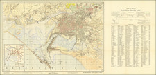
Survey of Pakistan Map of Pakistan Published Shortly After Independence. With East Pakistan.
Fine second edition of this early map to show Pakistan as an independent state. Published in 1953, following a 1950 first edition, the map was produced by the Survey General of Pakistan headquartered in Murree.
The central map shows Pakistan extending from the coast at Karachi up into the Himalayas. The border with Kashmir is notably unclear, as the Pakistani borders bleed into what was considered Indian territory.
The map shows two insets of non-contiguous Pakistani territory. The first shows East Pakistan, now Bangladesh, which was then part of the same country. Junagadh and Manavadar, which were occupied by India but claimed by Pakistan, are also shown. A third inset in the upper left shows a regional map. Tibet is independent, and Hyderbad is separated from India.
![[ Pakistan and Afghanistan ] Nona Asie Tabula [Ninth Map of Asia]](https://storage.googleapis.com/raremaps/img/small/101345.jpg)
![Tabula Asiae IX [Northern India & Pakistan]](https://storage.googleapis.com/raremaps/img/small/77557.jpg)