


|
||

|

|
|

|
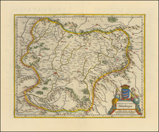
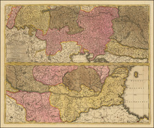
The Kingdom of Romania with Interesting Addition
Unrecorded second state of this important early map of Romania, prepared by the Romanian Army Geographical Service.
This second state is significantly improved and updated on the eve of the Balkan Wars. The map includes Southern Dobrudja and Northern Dobruja, which would be taken by Romania from Bulgaria in 1913, prior to the Treaty of Bucharest.
The primary change in the map is the addition of the city plans and inset maps, including the large Bucharest and smaller inset maps at the right. There are also new topographical details in Basarabia.
The present map is also heavily annotated to the east and northeast of Bucharest, with areas divided into sections and the size in Hectares given. The red lines shown in hectares would appear to relate to the areas that were part of the reforms of the rural colonization process in Wallachia, which took place at the end of the 19th century, after the sale of state-owned estates to peasants.
More generally the lines likely relate to the programs of agrarian reforms, which began in 1864 and lasted for over half a century. The reforms took place as a countermeasure to the the Organic Statutes in the 1830s which favored the large landowners to the detriment of the peasantry. The agrarian reform in 1864 was soon followed by the young married couple's landed property, a law that gave land to newly married peasants to settle thinly populated rural areas, in order to allow them to work the arable land. In Muntenia (Wallachia), most villages for newly married peasants were formed in Brăila, Râmnicu Sărat and Buzău, but also east of Bucharest.
By 1913, Romania was the world's fourth-largest wheat exporter, but the issue of inequitable land distribution became persistently troublesome. It was exacerbated that year when Romanian peasants fought in the Second Balkan War, witnessing first-hand the far more equitable land distribution scheme in place in Bulgaria. In the late 19th century about 2,000 landowners controlled over half the land while peasants (with little representation in government as well as limited access to land and ownership rights) had just a third. In 1888 peasant discontent with inequitable land distribution resulted in bloody confrontations that brought about partial and ineffective agrarian reforms. The unequal system continued to drive the peasantry into bankruptcy and seemed to lead increasingly toward a system of absentee ownership.
In 1907, the issue was a primary factor in the Romanian Peasants' Revolt, which almost caused a full-blown revolution and led to the deaths of several thousand peasants once the army intervened. As a consequence, the government introduced new legislation in 1907-08 to benefit the peasants, including a new law on agricultural contracts and a law establishing a rural credit bank (Casa Rurală) intended to facilitate purchases and leases, transferring property from large landowners to peasants. However, these laws were poorly enforced, a wholly inadequate amount of land was made available for purchase and the vast majority of the peasantry did not even qualify for most of the assistance made available.
Rarity
The map is very rare. This second state of the map appears to be unrecorded.
OCLC locates 4 examples of the first state (British Library, Paris Museum of Natural History, University of Wisconsin-Milwaukee/AGS Collection and University of Oxford. Popescu also lists an edition of 1899 in Proiectul feroviar românesc (1842-1916)
![[ Black Sea ] The Euxine or Black Sea From The Russian Survey of 1826](https://storage.googleapis.com/raremaps/img/small/99954.jpg)
![[ Greece & Balkans ] Northern Turkey & Europe &c.](https://storage.googleapis.com/raremaps/img/small/102178.jpg)