


|
||

|

|
|

|
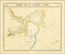
Russian Discoveries in the North Pacific and Alaska -- One of the Earliest Maps to Name Cook's Strait.
Rare map of the Russian explorations in the 1760s, published by Weygandsche Buchhandlung in Leipzig. The map appeared in the very rare first volume of the Beiträge zur Völker und Länderkunde Erster Theil, compiled by Johann Reinhold Forster and Matthias Christian Sprengel. This book was at the cutting edge of 18th-century cartography, helped along by Forster's extensive knowledge of recent explorations, having served as chief naturalist on Cook's second voyage.
Explicitly naming three Russian explorers (Ivan Synd, Pyotr Kuzmich Krenitsyn, and Mikhail Levashev), the map shows Kamchatka, the Chukchi Peninsula, western Alaska, and the Aleutians. Detail on the Aleutians, other southern islands, and the Siberian coastline appears to come from Russian sources, primarily Krenitsyn and Levashev. The introduction of the erroneous placements of some islands appears to source from Synd's work. Further north, the introduction of the very unusually named "Cook's Strait" and other island detail is from Cook.
The map's title translates as "Map showing the Russian discoveries in America according to the diaries of Krenizins, Lewaschefs, Synds and others . . . ," and it mostly concerns a chapter in Forster and Sprengel's book that publishes an excerpt of Captain Krenitsyn and Lieutenant Levashev's trip logs.
Detail on the map is surprisingly extensive. The Aleutians are termed the Fuch's islands, with Unalaska, then a Russian trading post, named. Many other islands are denoted, with volcanoes indicated. An unnamed island that was discovered during the Krenitsyn/Levashev expedition is shown. To the west, however, the location of islands is more haphazard, which is likely due to Ivan Synd's mismapping.
The islands shown near Cook's Strait correspond to those shown on comparable maps of Cook's voyages (e.g., Buache's map), although at a higher resolution. This is especially apparent in the naming of the "Anadyrische Inseln," which may indicate that Forster, a close collaborator with Cook as previously mentioned, may have been the first to publish this information. We have been unable to trace any earlier maps to show these islands, and they may come from personal correspondence between Forster and his colleagues who survived Cook's expedition. Forster and Spengel would discuss Cook in later volumes of their book, and include this map in a later volume. Here, they add detail to Alaska, but they change the name of the very unusual "Cook's Strait" (which only appears in a select few maps) to Behring's Strait.
Overview
In the 1760s, Russian fur traders discovered more and more of the Aleutian Islands, some of which are shown here. In 1764, Lieutenant Ivan Synd led his own voyage to the Bering Sea in search of a navigable passage from the Pacific through the Arctic. He produced several maps, all but one of which have been lost. The map that does survive shows a series of islands nearly touching Kamchatka, but his works are generally considered fallible by his contemporaries, and he introduced a number of phatnom islands.
The map also reports the discoveries of Pyotr Kuzmich Krenitsyn and Mikhail Levashev. Krenitsyn was a Russian explorer and officer in the Imperial Russian Navy. Following Vitus Bering's failed expedition of 1741, Krenitsyn was the first to conduct an expedition to Alaska and the Aleutians. Krenitsyn was sent, together with Mikhail Levashev, by Czarina Catherine II to explore the northern parts of the Pacific Ocean and particularly the area around the Bering strait in four ships in the late 1760s. Krenitsyn was the commander of the ship St. Catherine and Levashev commanded the ship St. Paul.
Krenitsyn and Levashev surveyed the eastern part of the Aleutian island chain until the cold weather set in. Krenitsyn wintered in the strait between Unimak and the Alaska Peninsula. Levashef wintered in a natural harbor in Unalaska. The following year, after resuming their surveys, both ships wintered in Kamchatka. Certain geographic features of the Alaskan coast, like Avatanak, Akutan and Tigalda Island were named by Krenitsyn in the maps that were subsequently published.
On July 4, 1770, Krenitsyn drowned in the Kamchatka River and Levashev assumed command of the Russian expeditionary fleet. The Krenitzin Islands and the highest volcano on Onekotan Island were named by Captain Mikhail Tebenkov after Krenitsyn.
Port Levashef, the harbor in Unalaska where Levashev had wintered his first year in the Northern Pacific, was named in honor of Levashev by Lieutenant Gavril Sarychev.
Rarity
The map is very rare. We note examples at the Niedersächsische Staats- und Universitätsbibliothek Göttingen and the ETH-Zurich Bibliothek. We note a complete copy of the book in the Czech National Library.


![[Alaska to San Diego and San Qunitin, British Columbia] A Chart Shewing Part of the Coast of N.W. America, with the Tracks of His Majesty's Sloop Discovery and Armed Tender Chatham . . . (First Modern Map of the West Coast of North America)](https://storage.googleapis.com/raremaps/img/small/102067.jpg)