|
||

|

|
|

|
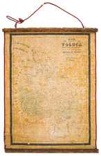
Gigantic Wall Map of the Region Around Mexico City
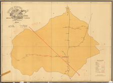
Rare six-foot-tall wall map of the Valle de Mexico, showing a highly detailed look at the surroundings of the country's capital. This map came at an important time in the history of the mapping of Mexico, being commissioned shortly after the Constitution of 1917 promoted the expansion of studies on the Mexican territory. The map was prepared by Luis Urquijo, chief of the division of coasts and seas for the governmental Directory of Geographical and Climatological Studies and published in 1919.
The map is particularly notable for the extent of the countryside it shows around Mexico City. While a number of maps of Mexico City of this size and extent exist from the era, it is very uncommon to see a regional map like this one. The 1919 date and the involvement of Pastor Rouaix explain the momentum behind mapping this region, as discussed further below.
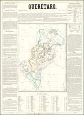
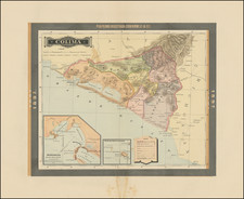
The map shows an area roughly three thousand square miles large, stretching from the National Parks and volcanoes south of the city northwards to Pachuca. Topography is shown, seven types of population centers are shown, and many other geographical details are indicated in the legend below the map. The limits of Mexico City are shown with red hachures. The city already stretches to Coyocan, but, northwards, the city is nowhere near as sprawling as it is today. The Texcoco lakebed can be seen to the east of the city, and the drainage canal is shown.
Pastor Rouaix and the Constitution of 1917
The Mexican Revolution and the 1917 Constitution of Mexico heralded a new era in the nation, one that secularized Mexican society, allowed for the growth of a Mexican middle class, and reshaped the political structure of the nation. Pastor Rouaix was one of the earliest politicians to redistribute land to peasants and he also helped draft articles in the Constitution relating to the nationalization of land.
This map served the purposes of Rouiax and the Constitution in several manners. First of all, it expanded the political outlook past Mexico City and allowed for the easier consideration of lands surrounding the nation's capital. Secondly, by mapping the land more thoroughly, the state could establish greater control over local production and encourage the growth of society here. Mexican institutions realized that the post-revolutionary era presented a valuable opportunity to explore regions more freely, record more accurately the resources and propose measures that allow their use and development to benefit the population. This map is a hallmark of that effort.
Rarity
OCLC lists four examples of the map.