|
||

|

|
|

|
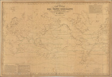
Blaeu’s Exquisite and Important Double-Hemisphere World Map
Fine example of Johannes Blaeu's scarce double-hemisphere map of the world, originally prepared by Blaeu for his Atlas Maior in 1662. This fantastic world map represents one of the most well-recognized works of the Dutch Golden Age of Cartography both for its decorative elements and for its geographical accuracy.
The map was much admired by Blaeu’s fellow mapmakers. It was included in contemporary composite atlases of the period, by Van Keulen, Goos, and others.
Unlike Blaeu's first world map, which appeared in the majority of his atlases and was plotted on the Mercator projection, here Blaeu utilizes a double-hemisphere format. The hemispheres are cleaved in the Atlantic, with the Americas in a western hemisphere and the old world of Africa, Asia, and Europe in an eastern hemisphere.
The geography displayed is a grand summary of the developments of cartography in the seventeenth century. California is depicted as an island. Anian is shown as an island separated from North America by a strait of the same name. Yesso (Hokkaido) and other phantom islands fill the northwest Pacific, while New Zealand has a partial coast glimpsed by Abel Tasman on his voyage of 1642.
Van Diemen’s Land floats south of mainland Australia. The rest of the continent is studded with place names of Dutch origin, a result of the VOC encounters with the continent on their way to the East Indies. Blaeu was the hydrographer of the Dutch East India Company and therefore had access to the most updated geographic knowledge about the Indian and Pacific Oceans.
The map is made to the highest standard, with especially fine engraving and layout. At the bottom are allegorical figures representing the seasons. Each season is shown riding on a chariot, with spring rich in bounty, summer holding golden wheat, autumn containing harvest abundance, and winter shown in chilly privation. At the top of the map are angels in varying degrees of repose and men of natural philosophy puzzling over instruments in the corners.
States and rarity
This second of Blaeu’s atlas world maps is rarer than the first, which is on a Mercator projection.
Recently, a variant plate of the Blaeu double-hemisphere map has been discovered, the present example is the standard Atlas Maior version. The variant can be quickly distinguished by the following characteristics: It includes two sailing ships off the west coast of South America and one ship off the southeastern coastline of South America. The ship below Australia is not present. The three flying fish at the center of the map, in the Atlantic, are also missing in the variant version of the map. There are more differences throughout; the map were printed on two different plates, not simply revisions to the same plate.
Because of the relative scarcity of this map and Blaeu's prominence as one of the most influential and decorative map makers of the Golden Age of Dutch Cartography, this map has become especially sought-after by collectors. It is increasingly scarce on the market.
The Dutch Golden Age and cartography
In the late 1500s, seven Dutch provinces in the northern Netherlands achieved independence from Spain and formed the Dutch Republic. Though the Dutch state was small and ruled by a decentralized system of control, it managed to cultivate a powerful seventeenth-century sea empire based on trade. This era became known as the Dutch Golden Age.
Due in large part to their powerful trade empire, the Dutch became known for cartography in the seventeenth century. Their publishing houses produced the highest quality work in Europe, particularly those maps and charts of foreign lands, and Dutch map-making set the bar for cartographic accuracy and artistry into the early-eighteenth century.
The Dutch in the East Indies
The vaunted Spice Islands, now known as the Moluccas were originally the only source in the world for nutmeg, mace, and cloves. The Portuguese were the first Europeans to gain power in the region, trading for spices in the Moluccas and controlling the spice market in Europe.
The Dutch wanted in on the lucrative trade, but they also had to contend with the Portuguese. The first Dutch expedition, led by Cornelis de Houtman in 1595, avoided India, the Strait of Malacca, and the Moluccas—Portuguese strongholds—in favor of the Sunda Strait. The Dutch set up their trade centers on the island of Java, at Bantam and, later, Batavia. After Houtman, the second Dutch expedition (1598-1600) quickly set sail for the East Indies. It was followed by five others; the Dutch merchants were eager to exploit the opportunity. In 1602, the most powerful of these merchants and the Dutch government, the States-General, created the Dutch East India Company (VOC), a monopoly to control the East Indies trade.
Joan, or Johannes, Blaeu (1596-1673) was the son of Willem Janszoon Blaeu. He inherited his father’s meticulous and striking mapmaking style and continued the Blaeu workshop until it burned in 1672. Initially, Joan trained as a lawyer, but he decided to join his father’s business rather than practice.
After his father’s death in 1638, Joan and his brother, Cornelis, took over their father’s shop and Joan took on his work as hydrographer to the Dutch East India Company. Joan brought out many important works, including Nova et Accuratissima Terrarum Orbis Tabula, a world map to commemorate the Peace of Westphalia which brought news of Abel Tasman’s voyages in the Pacific to the attention of Europe. This map was used as a template for the world map set in the floor of the Amsterdam Town Hall, the Groote Burger-Zaal, in 1655.
Joan also modified and greatly expanded his father’s Atlas novus, first published in 1635. All the while, Joan was honing his own atlas. He published the Atlas maior between 1662 and 1672. It is one of the most sought-after atlases by collectors and institutions today due to the attention to the detail, quality, and beauty of the maps. He is also known for his town plans and wall maps of the continents. Joan’s productivity slammed to a halt in 1672, when a fire completely destroyed his workshop and stock. Joan died a year later and is buried in the Westerkerk in Amsterdam.
![[17th Century Provenance!] Universalis Tabula Iuxta Ptolemaeum](https://storage.googleapis.com/raremaps/img/small/72635.jpg)
![The Western Hemisphere... [with:] The Eastern Hemisphere A Stereographical Projection on the Twentieth Meridian](https://storage.googleapis.com/raremaps/img/small/97573.jpg)
![[ Ancient World ] Christianographie](https://storage.googleapis.com/raremaps/img/small/80305.jpg)