


|
||

|

|
|

|
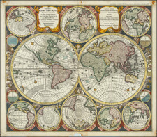
Fine Double-Hemisphere World Map, Combining the Latest Scientific Theories and Older Decorative Details
Striking double-hemisphere world map combining scientific diagrams with decorative imagery. Based on Carel Allard’s influential map of 1696, it features twelve smaller hemispheric and scientific projections framing the central maps.
The present map focuses on two central hemispheres surrounded by eight smaller, circular projections depicting the world from various orientations, as well as four circular scientific diagrams.
The projection on the left shows the Western Hemisphere. In North America, California is depicted as an island, and a vast northwestern coast, Terra Essonis, stretches off the map. In the South Pacific, a partial coastline can be seen for New Zealand and a large block of text explains the ecliptic and the constellations that lie along that line, the signs of the Zodiac.
The projection on the right shows the Eastern Hemisphere, with an easily-recognizable Europe and Africa; Asia’s eastern coastline is oddly smoothed and shortened. A distorted Japan has been fused with the conjectural landmass Terra Yedso. Compared to Allard’s map, the graticule is shifted east; that is, more of Oceania is included in this hemisphere, rather than in the western hemisphere.
Partial coastlines for Australia (Nova Hollandia), New Guinea, and surrounding lands are depicted in the Pacific. The shores of Australia are based on early Dutch encounters with the northern and western coastlines, and place names on the western coast are marked with their years of discovery. The Southern Atlantic and Indian Oceans remain conspicuously empty, noted only as Terra Australis Incognita, or “unknown southern land,” a departure from the grandiose southern continents often seen on earlier and even contemporary world maps.
Dotted lines crisscrossing both hemispheres, not present in Allard’s original map, trace important voyages of European encounter. One line traces Ferdinand Magellan’s quest to find a westward route to the Spice Islands via the southern tip of South America, departing Malaga, Spain, in August 1519, and returning (after the death of Magellan and much of the crew) in September 1522. Another important voyage traced is that of Abel Tasman in 1642 to Oceania, including observation of parts of the Australian coastline and the first European encounter with New Zealand.
In the top and lower center of the map, smaller circular projections depict the Northern and Southern Hemispheres. Seutter, like Allard before him, has chosen to leave the South Pole empty, rather than fill it with hypothetical beaches and lands. Two small polar projections appear at the bottom of the map. Four small circular scientific diagrams are depicted at the outer corners of the twin hemispheres. The diagram in the upper left depicts lines of latitude and longitude, while the diagrams in the other three corners show the relationship between the zenith, the nadir, and different horizons.
Circular projections in the four corners of the map show the world from slightly different, oblique or optical orientations. These allow viewers to understand which landmasses are antipodal to certain points. The figure in the upper left shows the antipodes of Amsterdam, with Amsterdam on the hemisphere in the upper right corner (this is stated explicitly in Allard’s map of 1696, but is merely implied here.) The two hemispheres in the bottom corners show the world as if in 3-D, with the meridians curved to show the world as round, rather than flattened as many map projections do.
Finally, there are several decorative features in the map. While the map lacks the lushly illustrated border scenes common in maps of the previous century, it incorporates more decorative detail than the Allard map it is based on. Surrounding the map, twelve wind heads peer out from the darkness, based upon the twelve classical wind heads from antiquity. The two cartouches at the top of the map add further decorative flourishes.
The present map appeared in the first edition of Seutter’s Atlas Novus sive Tabulae Geographicae, first published in Augsburg in 1720. As stated above, this map is based on Carel Allard’s 1696 double-hemisphere world map. Similar maps were produced by fellow eighteenth-century mapmakers such as Pieter Schenk, Adam Friedrich Zürner, and Johann Homann.
Exploration and Conjecture in the Pacific
The present map contains several noteworthy features in the Pacific Ocean. Australia is less accurately depicted than in Allard’s map; it is suggestively connected to surrounding landmasses with incomplete coastlines. Carpentaria, named for Pieter de Carpentier, governor-general (1623–27) of the Dutch East Indies extends toward New Guinea.
North of Carpentaria is Nova Britania, and a note indicates it was discovered by English buccaneer William Dampier, who explored the north and west coasts of Australia in 1688 and 1699. Dampier was a buccaneer, pilot, and natural historian who was also the first person to circumnavigate the world three times.
South of Australia is Diemens Land, named by Abel Tasman for his commander, Anthony van Diemen, governor-general (1636–45) of the Dutch East Indies. In the lower left of the left projection, the incomplete coastline of New Zealand also references Abel Tasman. Anthony van Diemen is again honored here, with Cape Maria van Diemen being named by Tasman after van Diemen’s wife. Unlike in Allard’s map, Quiri Regio, named after Portuguese explorer Pedro Fernandes de Quiros and corresponding to present-day Vanuatu, is not present.
The northern Pacific also includes interesting geographic elements, reflective of information gleaned from the 1643 voyage of Maarten Gerritszoon de Vries, a Dutch explorer for the VOC. De Vries is credited with charting islands and promontories north of Japan, which were then believed to be part of America. In the right projection, an enlarged Hokkaido is clearly labeled as Yedso and is connected to the misshapen Japanese mainland. Unlike in Allard’s map, Yedso does not stretch east to connect to Terra Essonis, the vast, empty expanse of land stretching westward off of North America. Interestingly, though, Terra Essonis does appear connected to Yedso and Japan in the smaller projections on either side of the right cartouche at the top of the map, and second to right at the bottom. These smaller projections match Allard’s depiction.
The origin of Terra Essonis is tangled with that of Compagnie Land, a conjectural landmass not depicted in Allard’s map. In 1589, Portuguese explorer João da Gama fled the East Indies to escape sentencing for illegally trading oriental silks with the Spanish for South American gold. Sailing east, da Gama reported the existence of an uninterrupted coast northeast of Japan stretching from Asia to North America. A dotted line tracing da Gama’s voyage runs along the coast of Terra Essonis.
Da Gama’s claim was also sometimes depicted on maps as a series of islands or a landmass called Gamaland. Gamaland was searched for by several explorers, including the aforementioend Maarten Gerritszoon de Vries in 1643. While searching for Gamaland, de Vries found two “new” islands—Compagnie Land (named in honor of the Dutch East Indies Company) and Staaten Land (named after the Dutch States General). These islands correspond to Iturup and Urup, part of the volcanic Kuril Islands in the Sea of Okhotsk. Compagnie Land was sometimes taken as proof of the existence of Gamaland, and, along with Terra Essonis, continued to appear on maps long after da Gama’s death in ca. 1592, as evidenced by this map created more than a century later.
As far as evidence of the fabled Northwest Passage linking Europe to Asia above or across North America, this map portrays the “Fretum Anian” (Straits of Anian) separating Terra Essonis and California, but it does not depict where the straits lead to in the north. The Straits of Anian were believed to mark the separation between Asia and North America, which would be disproven in the mid-eighteenth century with the discovery of the Bering Strait.
North Pacific chimeras: Yesso, De Gama, and Compagnie Land
The etymology of the idiom Yesso (Eso, Yeco, Jesso, Yedso) is most likely the Japanese Ezo-chi; a term used for the lands north of the island of Honshu. During the Edō period (1600-1886), it came to represent the ‘foreigners’ on the Kuril and Sakhalin islands. As European traders came into contact with the Japanese in the seventeenth century, the term was transferred onto European maps, where it was often associated with the island of Hokkaido. It varies on maps from a small island to a near-continent sized mass that stretches from Asia to Alaska.
The toponym held interest for Europeans because the island was supposedly tied to mythic riches. Father Francis Xavier (1506-1552), an early Jesuit missionary to Japan and China, related stories that immense silver mines were to be found on a secluded Japanese island; these stories were echoed in Spanish reports. The rumors became so tenacious and tantalizing that Abraham Ortelius included an island of silver north of Japan on his 1589 map of the Pacific.
Yesso is often tied to two other mythical North Pacific lands, Gamaland and Compagnies Land. Juan de Gama, the grandson of Vasco de Gama, was a Portuguese navigator who was accused of illegal trading with the Spanish in the East Indies. Gama fled and sailed from Macau to Japan in the later sixteenth century. He then struck out east, across the Pacific, and supposedly saw lands in the North Pacific. These lands were initially shown as small islands on Portuguese charts, but ballooned into a continent-sized landmass in later representations.
Several voyagers sought out these chimerical islands, including the Dutchmen Matthijs Hendrickszoon Quast in 1639 and Maarten Gerritszoon Vries in 1643. Compagnies Land, often shown along with Staten Land, were islands sighted by Vries on his 1643 voyage. He named the islands for the Dutch States General (Staten Land) and for the Dutch East India Company (VOC) (Compagnies, or Company’s Land). In reality, he had re-discovered two of the Kuril Islands. However, other mapmakers latched onto Compagnies Land in particular, enlarging and merging it with Yesso and/or Gamaland.
In the mid-eighteenth century, Vitus Bering, a Danish explorer in Russian employ, and later James Cook would both check the area and find nothing. La Perouse also sought the huge islands, but found only the Kurils, putting to rest the myth of the continent-sized dream lands.
The popular misconception of California as an island can be found on European maps from the sixteenth through the eighteenth centuries. From its first portrayal on a printed map by Diego Gutiérrez, in 1562, California was shown as part of North America by mapmakers, including Gerardus Mercator and Abraham Ortelius. In the 1620s, however, it began to appear as an island in several sources. While most of these show the equivalent of the modern state of California separated from the continent, others, like a manuscript chart by Joao Teixeira Albernaz I (ca. 1632) now in the collection of the National Library of Brasil shows the entire western half of North Americas as an island.
The myth of California as an island was most likely the result of the travel account of Sebastian Vizcaino, who had been sent north up the shore of California in 1602. A Carmelite friar, Fray Antonio de la Ascensión, accompanied him. Ascension described the land as an island and around 1620 sketched maps to that effect. Normally, this information would have been reviewed and locked in the Spanish repository, the Casa de la Contratación. However, the manuscript maps were intercepted in the Atlantic by the Dutch, who took them to Amsterdam where they began to circulate. Ascensión also published descriptions of the insular geography in Juan Torquemada’s Monarquia Indiana (1613) (with the island details curtailed somewhat) and in his own Relación breve of ca. 1620.
The first known maps to show California as an island were on the title pages of Antonio de Herrera’s Descripción de las Indias Occidentales (1622) and Jacob le Maire's Spieghel Der Australische Navigatie (1622). Two early examples of larger maps are those by Abraham Goos (1624) and another by Henry Briggs, which was included in Samuel Purchas’ Hakluytus Posthumus or Purchas his Pilgrimes (1625). In addition to Briggs and Goos, prominent practitioners like Jan Jansson and Nicolas Sanson adopted the new island and the practice became commonplace. John Speed’s map (1626-7), based on Briggs’ work, is well known for being one of the first to depict an insular California.
The island of California became a fixture on mid- and late-seventeenth century maps. The island suggested possible links to the Northwest Passage, with rivers in the North American interior supposedly connecting to the sea between California and the mainland. Furthermore, Francis Drake had landed in northern California on his circumnavigation (1577-80) and an insular California suggested that Spanish power in the area could be questioned.
Not everyone was convinced, however. Father Eusebio Kino, after extensive travels in what is now California, Arizona, and northern Mexico concluded that the island was actually a peninsula and published a map refuting the claim (Paris, 1705). Another skeptic was Guillaume De L’Isle. In 1700, De L’Isle discussed “whether California is an Island or a part of the continent” with J. D. Cassini; the letter was published in 1715. After reviewing all the literature available to him in Paris, De L’Isle concluded that the evidence supporting an insular California was not trustworthy. He also cited more recent explorations by the Jesuits (including Kino) that disproved the island theory. Later, in his map of 1722 (Carte d’Amerique dressee pour l’usage du Roy), De L’Isle would abandon the island theory entirely.
Despite Kino’s and De L’Isle’s work, California as an island remained common on maps until the mid-eighteenth century. De L’Isle’s son-in-law, Philippe Buache, for example, remained an adherent of the island depiction for some time. Another believer was Herman Moll, who reported that California was unequivocally an island, for he had had sailors in his offices that claimed to have circumnavigated it. In the face of such skepticism, the King of Spain, Ferdinand VII, had to issue a decree in 1747 proclaiming California to be a peninsula connected to North America; the geographic chimera, no matter how appealing, was not to be suffered any longer, although a few final maps were printed with the lingering island.
Matthäus Seutter (1678-1757) was a prominent German mapmaker in the mid-eighteenth century. Initially apprenticed to a brewer, he trained as an engraver under Johann Baptist Homann in Nuremburg before setting up shop in his native Augsburg. In 1727 he was granted the title Imperial Geographer. His most famous work is Atlas Novus Sive Tabulae Geographicae, published in two volumes ca. 1730, although the majority of his maps are based on earlier work by other cartographers like the Homanns, Delisles, and de Fer.
Alternative spellings: Matthias Seutter, Mathaus Seutter, Matthaeus Seutter, Mattheus Seutter
![[Mussolini Celebrates Pearl Harbor] Grande Carta Del Pacifico](https://storage.googleapis.com/raremaps/img/small/65273.jpg)
![[ Volcanic Regions ] Geografia Dei Vulcani Accesi Ed Estinti](https://storage.googleapis.com/raremaps/img/small/101861.jpg)
![[ Original Artwork ] Carriers of the New Black Plague](https://storage.googleapis.com/raremaps/img/small/101825.jpg)