|
||

|

|
|

|
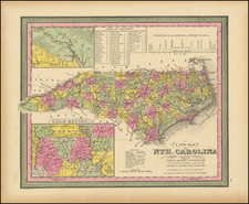
Rare Early Edition of the Field Lucas Map of North Carolina
Nice example of Fielding Lucas' early map of North Carolina, from his New & Elegant General Atlas of the United States . . .
The map is hand colored by counties, with a large inset of western North Carolina. A striking example of Fielding Lucas' fine work, which distinguished him as the best publisher of the era.
This is one of the first maps of North Carolina printed in America. This is the first time we have ever offered this first edition of the map.
As noted by Jay Lester on the North Carolina map blog:
[Lucas's map of" “N. Carolina” was unchanged throughout the publication history of A New and Elegant Atlas. The map was drawn by Samuel Lewis and engraved by Henry Tanner. . . For the Lucas atlas map, Lewis drew heavily from the 1808 Price-Strother map [which] was based on 1799 and earlier surveys. Lewis depicts sixty (of 62) counties, omitting Haywood and Columbus (both established in 1808). Like Price-Strother, Lewis shows Glasgow instead of Greene County. The name had been changed in 1799, likely after that portion of the Price-Strother manuscript had been completed. On the Lucas atlas map, Chatham County is shown, but unnamed. . . .
This is the first time we have ever offered this first edition of the map.
Fielding Lucas, Jr. (1781-1854) was a prominent American cartographer, engraver, artist, and public figure during the first half of the 19th century.
Lucas was born in Fredericksburg, Virginia and moved to Philadelphia as a teenager, before settling in Baltimore. There he launched a successful cartographic career. Lucas's first atlas was announced in early- to mid-1812, with production taking place between September 1812 and December of 1813, by which point the engravings were complete. Bound copies of the atlas -- A new and elegant general atlas: Containing maps of each of the United States -- were available early in the next year, beating Carey to market by about two months. Lucas later published A General Atlas Containing Distinct Maps Of all the known Countries in the World in the early 1820s.
![[French Colonization in Florida and the Southeast] La Floride Francoise Dressee sur La Relation des Voiages que Ribaut, Laudonier, et Gourgues y ont faits in 1562, 1564 et 1567 . . .](https://storage.googleapis.com/raremaps/img/small/91072.jpg)
![[Carolina]](https://storage.googleapis.com/raremaps/img/small/89687.jpg)