|
||

|

|
|

|
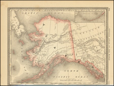
Perhaps the Earliest Surviving Guide Map for the Nome Gold Rush -- Prepared by an Early Participant
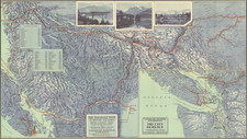
Fascinating map and miner's outfitting guide for the Gold Regions of Northwestern Alaska, published by H.S. Crocker Company of San Francisco in 1899 and offered forsale by J.H. James, St. Michael, Golvin Bay and Nome Alaska, bearing the copyright 1899.
The map and guide are "copyrighted by D.A. MacDonald," who was apparently one of the earliest "witnesses" to report on the discovery of gold on the Anvil River in 1898. It is without question one of the earliest and rarest of the gold mining guide maps for the Nome Gold Rush and one of the few (if not the only) guide map prepared by a contemporary witness to the earliest reports of the gold discoveries in the region. OCLC locates only 3 maps for the gold regions printed in 1899 (both known in only 1 or 2 examples).
The Nome Gold Rush (1899-1909) commenced in September 1898, when the "Three Lucky Swedes": Norwegian-American Jafet Lindeberg, and two American citizens of Swedish birth, Erik Lindblom and John Brynteson, discovered gold on Anvil Creek and founded Nome mining district. Several men around the trading post at Golovin were early participants, including Missionary minster Nils Hultberg, a doctor, A. N. Kittilsen, sometimes manager of the reindeer station at Port Clarence. On one prospecting venture in the summer of 1898, Hultberg, mining engineer H.L. Blake (who would later make a report to Congress on the Nome Gold Rush in June 1900), John Brynteson and others discovered gold on the Snake River; Hultberg also later claimed to have found gold at Anvil Creek at this time, but did not tell Blake, an episode reported to Congress by Blake through the testimony of Dan. H. MacDonald, the likely author of this map and guide.
News of the discovery reached the outside world that winter. By 1899, Nome had a population of 10,000 many of whom had arrived from the Klondike gold rush area. In that year, gold was found in the beach sands for dozens of miles along the coast at Nome, which spurred the stampede to new heights.
The present guide includes an Interesting set of maps (one one sheet) including a general map of the area around Norton Sound, and three detailed maps showing the mining regions around Nome, Council City and the Anvik River. It includes a note that it is:
Compiled from correct observations taken on the ground during 1897 and 1898 and from data furnished by Edwin Engelstad and John A Dexter, the best authorities in Northwestern Alaska, both of whom are pioneer travelers in the country. Accepted by the Officer in command of the Military Forces at Fort St. Michael for the War Department at Washington, D.C.
Inset maps include:
- Cape Nome Mining District
- El Dorado & Discovery Mining District
- Golsan Mining District/Anvil River
Thomas Streeter, in his discussion of Map Cape Nome Gold Fields Alaska Showing "Bonanza," "Cape Nome," "Cripple," "Sinock," "Fairview" and Cape York Mining Districts Compiled by Gustaf Nordblom, published in Seattle and copyrighted on November 18, 1899 (Streeter 3602), noted that "This must be about the first map of the Nome mining region". Its author was a Swedish artist who was then living in the Klondyke region.
D.A. MacDonald
While we were unable to find much information on DA MacDonald, we believe him to be the same person as Dan. H. MacDonald, who gave an affadavit on the discovery of gold in the Cape Nome area, which was reported in theCongressional Report on the June 5, 1900 paper entitled History of the Discovery of Gold at Cape Nome, by H.L. Blake, 56tgh Congress, 1st Session, Document No. 441. Taken in Anvil City, Alaska on September 13, 1899, MacDonald testified that:
. . . on or about the 16th day of July, 1898 , while stopping at St. Michael, I became acquainted with Mr. H. L. Blake, who had just returned from a prospecting trip from what is now known as the Cape Nome mining district, Alaska. . . . Blake told me he had [found gold], and that on many of the streams in that region gold could be found in paying quantities, and asked me as well as others to go with him and more thoroughly prospect; that he was so lonesome, there being no white men in that section of the country at that time, other than a trader and a Swedish missionary. That he was afraid to trust the missionary, for he had deceived him on several occasions, which statement I found out later to be true. That while said Blake was in St. Michael on business, O. N. Hultburg, the Swedish missionary quietly arranged with the United States commissioner to naturalize some 20 or 30 Laplanders, and give each one his and also the United States commissioner's power of attorney, then to hasten to Cape Nome and stake all the claims they possibly could before said Blake could return from St. Michael, knowing full well that said H. L. Blake was going to inform several American friends of his at St. Michael. . . .
The Rasmussen Library (University of Alaska-Fairbanks) special collections includes a literary notebook with essays and poetry written between 1897 and 1917, the bulk of which were written by D.A. MacDonald, along with his wife, Elizabeth. The theme of the poetry and essays is life in the far north, Alaska, and the Klondike during the Alaskan and Klondike gold rushes. Also included with the materials are photographs and newsclippings.
Rarity
The map is extremely rare. We note no other examples at auction or in dealer catalogs listed by AMPR and RBH.
OCLC notes copies at the University of Alaska (Fairbanks and Anchorage), Alaska State Library, Huntington Library, Wisconsin Historical Society and National Geographic Library.