


|
||

|

|
|

|
Fine Original Color
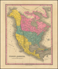
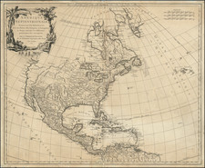
Fine full original color example of the first edition of Rossi's map of North America.
Offered here in full original Italian color -- a rare survival, especially in such fine condition
Rossi's map of North America is based upon Sanson's seminal map, but with revised Italian nomenclature.
Includes a detailed California as an Island on Sanson's model, early open ended Great Lakes (one of the earliest appearances of the 5 Great Lakes) and a mislocated pre-La Salle/Jolliet/Hennepin projection of the Mississippi River, pushed well west of its true location and quite speculative in its course. Nice detail in the Spanish Southwest along the Rio Grande, locating Taos and Santa Fe in the North and identifying Cibola.
A number of early Indian names, including the Apaches and Zuni appear. A Lago de Oro is shown off the Gulf of California. Quivera appears in modern day Texas, along with Granada. The East Coast of North America includes many early place names, including N. Amsterdam, Chesapeac, Powhata, Gotheburg (an early Swedish Settlement), Bristou London, Plimouth, Nassau, Elsinburg, R. Iourdain, etc.
The first edition can be distinguished from the later editions by the date (which is changed to 1687 in later editions). From Rossi's Mercurio Geographico….
The popular misconception of California as an island can be found on European maps from the sixteenth through the eighteenth centuries. From its first portrayal on a printed map by Diego Gutiérrez, in 1562, California was shown as part of North America by mapmakers, including Gerardus Mercator and Abraham Ortelius. In the 1620s, however, it began to appear as an island in several sources. While most of these show the equivalent of the modern state of California separated from the continent, others, like a manuscript chart by Joao Teixeira Albernaz I (ca. 1632) now in the collection of the National Library of Brasil shows the entire western half of North Americas as an island.
The myth of California as an island was most likely the result of the travel account of Sebastian Vizcaino, who had been sent north up the shore of California in 1602. A Carmelite friar, Fray Antonio de la Ascensión, accompanied him. Ascension described the land as an island and around 1620 sketched maps to that effect. Normally, this information would have been reviewed and locked in the Spanish repository, the Casa de la Contratación. However, the manuscript maps were intercepted in the Atlantic by the Dutch, who took them to Amsterdam where they began to circulate. Ascensión also published descriptions of the insular geography in Juan Torquemada’s Monarquia Indiana (1613) (with the island details curtailed somewhat) and in his own Relación breve of ca. 1620.
The first known maps to show California as an island were on the title pages of Antonio de Herrera’s Descripción de las Indias Occidentales (1622) and Jacob le Maire's Spieghel Der Australische Navigatie (1622). Two early examples of larger maps are those by Abraham Goos (1624) and another by Henry Briggs, which was included in Samuel Purchas’ Hakluytus Posthumus or Purchas his Pilgrimes (1625). In addition to Briggs and Goos, prominent practitioners like Jan Jansson and Nicolas Sanson adopted the new island and the practice became commonplace. John Speed’s map (1626-7), based on Briggs’ work, is well known for being one of the first to depict an insular California.
The island of California became a fixture on mid- and late-seventeenth century maps. The island suggested possible links to the Northwest Passage, with rivers in the North American interior supposedly connecting to the sea between California and the mainland. Furthermore, Francis Drake had landed in northern California on his circumnavigation (1577-80) and an insular California suggested that Spanish power in the area could be questioned.
Not everyone was convinced, however. Father Eusebio Kino, after extensive travels in what is now California, Arizona, and northern Mexico concluded that the island was actually a peninsula and published a map refuting the claim (Paris, 1705). Another skeptic was Guillaume De L’Isle. In 1700, De L’Isle discussed “whether California is an Island or a part of the continent” with J. D. Cassini; the letter was published in 1715. After reviewing all the literature available to him in Paris, De L’Isle concluded that the evidence supporting an insular California was not trustworthy. He also cited more recent explorations by the Jesuits (including Kino) that disproved the island theory. Later, in his map of 1722 (Carte d’Amerique dressee pour l’usage du Roy), De L’Isle would abandon the island theory entirely.
Despite Kino’s and De L’Isle’s work, California as an island remained common on maps until the mid-eighteenth century. De L’Isle’s son-in-law, Philippe Buache, for example, remained an adherent of the island depiction for some time. Another believer was Herman Moll, who reported that California was unequivocally an island, for he had had sailors in his offices that claimed to have circumnavigated it. In the face of such skepticism, the King of Spain, Ferdinand VII, had to issue a decree in 1747 proclaiming California to be a peninsula connected to North America; the geographic chimera, no matter how appealing, was not to be suffered any longer, although a few final maps were printed with the lingering island.
Giacomo Giovanni Rossi (1627-1691) was an Italian engraver and printer. He worked in Rome, the heir to an important printing business founded by his father, Giuseppe de Rossi (1570-1639). Giuseppe began the press in 1633 and Giovanni and his brother, Giandomenico (1619-1653) took it over upon his death. The brothers expanded the business and by the mid-seventeenth century it was the best-known printing house in Rome.
For his maps, Giovanni worked with Giacomo Cantelli da Vignola. They produced the Atlas Mercurio Geografico. The first edition is undated, but the second was issued in 1692, a year after Giovanni’s death. The maps were by Cantelli. The firm also published maps based on those of Nicolas Sanson.
Later, the business passed to Lorenzo Filippo (1682-?). By 1738, the firm was known as Calcografia Camerale, then, from 1870 to 1945, as the Regia Calcografica. Today, the firm is still in business and is called Calcografia Nazionale. It operates as a free museum and offers one of the best collections of prints and plates in the world.

![Tabula Terre Nove [The Admiral's Map]](https://storage.googleapis.com/raremaps/img/small/81714.jpg)