|
||

|

|
|

|
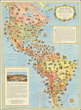
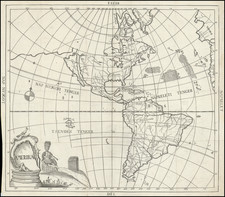
Attractive map of the Western Hemisphere, showing numerous explorers tracks throughout the hemisphere, including La Maire, St. Louis, Haley, Quiros, Marquises de Mardoe, Magellan, Abel Tasman, Antoine de Perou and others. The primary activities are in Pacific Ocean, where numerous new southern Islands and the NW Coast of America are changing radically. This map illustrates the Sea of the West and the massive conjectural Alaskan Archipelago, which would soon disappear until it was explored and rediscovered at the beginning of the 19th Century. Over the next 25 years, Cook, La Perouse, Vancouver, Meares and others would radically redefine the body of knowledge of these areas.
Louis Brion de la Tour (ca. 1743-1803) was a French geographer and demographer. Little is known about Louis’ early life, but some glimpses of his professional life survive. He did achieve the title of Ingénieur Géographe du Roi. Much of his work was done in partnership with Louis Charles Desnos, who was bookseller and geographical engineer for globes to the Danish Crown. He worked on the Indicateur fidèle ou guide des voyageurs, qui enseigne toutes les routes royales between 1762 and 1785. During his career he also worked on several atlases. By 1795, he had gained a pension from the National Assembly. Perhaps this pension was granted in part because his son, also Louis Brion de la Tour (1763-1823), was an engraver who made Revolutionary prints, as well as maps.