


|
||

|

|
|

|
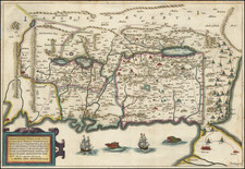
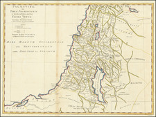
Detailed map of the Holy Land, colored by tribes and showing scripture names, classical names, modern names, roads, and other features.
The map extends southwards towards "Idumea or Edum" (Edom), a kingdom that lasted in the Babylonian region from the thirteenth century to the sixth century, before being pushed toward the location shown on the map. In the north, the map reaches modern-day Syria and Lebanon. Both Biblical and modern names are included, and archeological discoveries are shown, such as the "Ruins of an Ancient City" just south of Simeon.
The map includes an interesting inset of Arabia Petraea (the Sinai Peninsula). The map includes a nice decorative border and is attractively designed.
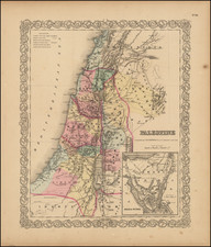
In all, a terrific regional map, from Joseph Colton, one of the most prolific American mapmakers of the mid-19th century.
G. W. & C. B. Colton was a prominent family firm of mapmakers who were leaders in the American map trade in the nineteenth century. The business was founded by Joseph Hutchins Colton (1800-1893) who bought copyrights to existing maps and oversaw their production. By the 1850s, their output had expanded to include original maps, guidebooks, atlases, and railroad maps. Joseph was succeeded by his sons, George Woolworth (1827-1901) and Charles B. Colton (1831-1916). The firm was renamed G. W. & C. B. Colton as a result. George is thought responsible for their best-known work, the General Atlas, originally published under that title in 1857. In 1898, the brothers merged their business and the firm became Colton, Ohman, & Co., which operated until 1901, when August R. Ohman took on the business alone and dropped the Colton name.