|
||

|

|
|

|
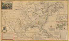
Naming Texas and "Gavlezton" in 1830!
Large, unusual, and impressive school girl manuscript map of the United States, drawn by Elizabeth Simmons of Duxbury, Massachusetts in 1830.
This map is differentiable from others of its kind for its large scale (it is about 3 feet wide and 2 feet tall), for its treatment of the West generally and Texas specifically, and for its interesting schematic style.
The map covers the entire eastern United States (less southern Florida), as well as Louisiana, "Arkansaw Territory", Missouri, "North West Territory", and portions of Louisiana Territory and Texas. The map features delineations of the states and territories, names of some important topographic features, as well as those of large towns. Names of Indian tribes, such as the Lower Creeks and Cherokees in Georgia, are also present.
Texas is shown and the names of some of its rivers and settlements are also provided. Including "Galvezton", which, although founded in 1816, rarely shows up on maps of this vintage. San Antonio, "Pres. del Altar", and "Nacogdches" are also named.
According to a search in Ancestry.com, Elizabeth Simmons was born in Massachusetts in 1818 (having drawn this map 12 years later in 1830) to parents William Simmons and his wife. She apparently died in 1848, at the age of 30, in Salem.