|
||

|

|
|

|
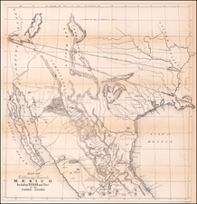
Selling Railroad Land in West Texas. Only One Copy in OCLC. None in Texas.
Large, detailed railroad land map of west Texas, stretching approximately from Cisco to Midland, following the route of the Texas & Pacific through Abilene, Sweetwater, Big Spring, etc. (along the route of Highway 20 today).
The map's purpose was to illustrate and market the unsold grant lands of the Texas & Pacific Railway in west Texas "between Callahan and Martin Counties." It was printed by Woodward, Tiernan & Hale of St. Louis based on work by the draughtsman M. Stakemann.
Interestingly, many of the town names along the route have changed since the map was made. For instance, "Midway" must now be Midland, Texas. Most if not all of the towns west of Big Spring either no longer go by the names shown here or no longer exist at all.
A similar map of T&P land, issued in Dallas in 1885, calls Midland by its current name, indicating that the present map probably predates 1885.
The T&P grant grew much wider at a certain point in west Texas (earlier maps put that point farther east than the present). Much of the land was not sold off and now forms the basis of the Texas & Pacific Land Corporation, which has land holdings in 20 Texas counties and is one of the largest landowners in Texas.
Rarity
OCLC locates a single copy, at UC Berkeley.

![[ Texas Pictorial Map Artwork ]](https://storage.googleapis.com/raremaps/img/small/65261.jpg)