|
||

|

|
|

|
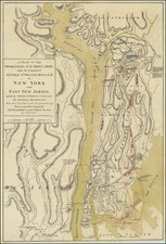
Scarce regional map showing the field of military operations during the Revolutionary War, engraved by John Lodge for the Political Magazine.
The map shows the various boundary disputes between New York and New Jersey, roads, forts, land grants and Indian territory. Vermont is labeled "The Hampshire Grants or the New Erected State of Vermont," with the Pulteney Township, Arlington Township and Bennington Township shown.
The depiction of Lake Champlain is quite unusual and relies primarily upon French sources from the French & Indian War period. The road system adjacent to the Hudson River and Mohawk River Valley is quite well delineated.
A large area of upstate New York is labeled "Hunting Grounds of the Iroquois or The Mohawk Indians Ceded to the English."
The map also provides 3 possible boundary lines for the border between New Jersey and New York.
![(New York-Robert C. Livington) [Revolutionary-Era Land Indenture]](https://storage.googleapis.com/raremaps/img/small/91957.jpg)
![[Niagara Falls] Wasserfall von Niagra](https://storage.googleapis.com/raremaps/img/small/69038.jpg)