|
||

|

|
|

|
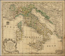
Illustrating the Eruptions of Mount Aetna and Mount Vesuvius
Highly decorative map of Italy, published in London by Emanuel Bowen in the mid-18th century for his A Complete System of Geography. The map shows two fantastic representations of volcanoes, with high, fiery plumes of smoke rising above Catania and Naples.
The map itself is highly detailed, with cities, rivers, geographical features, and decorative elements all included. Notes abound, and Bowen credits de Maurepas, Riccioli, and Delisle as his sources. The cartouche shows a cardinal on the outskirts of Rome.
The two eruptions shown at the bottom of the map are those of Mt. Etna in 1669 and an updated eruption of Mt. Vesuvius, which had recently entered a phase of heightened activity in 1631. These two frightening views include detailed notes regarding various Etna eruptions, describing the damage to Catania.
Emanuel Bowen (1694?-1767) was a British engraver and print seller. He was most well-known for his atlases and county maps. Although he died in poverty, he was widely acknowledged for his expertise and was appointed as mapmaker to both George II of England and Louis XV of France. His business was carried on by his son, Thomas Bowen. He also trained many apprentices, two of whom became prominent mapmakers, Thomas Kitchin and Thomas Jeffreys.

![[Italy Under the Reign of Augustus] Tabula Italiae Antiquae in Regionis XI ab Augusto divisae et tum ad mensuras itinerarias tum ad observationes astronomicas exactae . . . M.D. CCXV. Aug 26. . . . 1745](https://storage.googleapis.com/raremaps/img/small/77622.jpg)