|
||

|

|
|

|
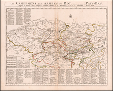
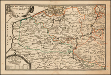
Striking regional map of Northwestern Belgium, centered on Ghent.
The map extends south to the region of the Dender River and east to the Schelde River and the area around Vlissingen.
Embellished with two cartouches, which include a total of 3 coats of arms and a dedication to Sir Joseph Williamson (1633-1701), an English civil servant, diplomat and politician who sat in the House of Commons of England variously between 1665 and 1701 and in the Irish House of Commons between 1692 and 1699. He was Secretary of State for the Northern Department 1674–79. During the Third Anglo-Dutch War, he drew up plans for the Zealand Expedition which was intended to land a newly formed English Army in the Netherlands. The strategy was abandoned after the naval defeat at the Battle of Texel and the Treaty of Westminster which ended the war. Just before his removal from the post of Secretary of State, he was arrested on a charge of being implicated in the Popish Plot, but he was at once released by order of Charles II. Williamson was a particular target of the informers because he was one of the few Ministers who openly disbelieved in the Plot. When Israel Tonge first approached him with "information", Williamson, who believed, with some reason, that Tonge was insane, gave him a "rude repulse". As for the other informers, several of whom were members of London's criminal underworld, his efficient intelligence service no doubt told him everything necessary about their characters. For this reason, the King, who was equally skeptical about the Plot's reality, wished to retain his services, at least in the short term. The actual charge made against Williamson, of commissioning Roman Catholic army officers, was entirely spurious since these officers were intended for foreign service.
Williamson's nerve began to give way under the strain of the Plot, and he became a political liability. Charles finally dismissed him after he gave orders to search Somerset House, the Queen's official residence, without the King's permission; the King, "in great anger" told him that "I marvel at your effrontery in searching my house... your head is turning.....I do not wish to be served by a man who fears anyone more than me". Danby was suspected by many of having a part in Williamson's downfall, as he was said to have taken offence at Williamson's recent marriage to Lady Clifton, a wealthy widow and cousin of the King.
The map retains the dedication cartouche from when it was published by Moses Pitt in London, but this example is a later state, which also includes the imprint of Valk & Schenk.
Pitt was from Cornwall, where he was baptized at St. Teath in 1639. He was educated locally but moved to London when apprenticed to bookseller Robert Littlebury. At the end of his apprenticeship, in 1661, he was made free of the Haberdasher’s Company. His first books to be published with his own imprint appeared in 1667.
Pitt specialized in learned publications and imported scholarly works from continental Europe. He also published the writings of members of the newly formed Royal Society, including Robert Boyle, as well as high-ranking clergymen. In 1678, Pitt was the first bookseller to offer his wares via an auction.
Thanks in part to his ties to the Royal Society, Pitt announced in 1678 that he would publish a massive twelve-volume atlas of the world. The plates were to be based on Dutch maps, with a text written by Bishop William Nicholson and Richard Peers. However, only four volumes ever appeared.
Pitt, who was also managing several properties in Westminster and had expanded in a partnership to Oxford, was spread too thin. The cost of each volume of the atlas alone Pitt estimated at £1,000. One by one, his ventures turned foul, landing him in debtors’ prison for seven years. He died in London, but not in prison, in 1697.
![[Ptolemy's France] Europ III Tab](https://storage.googleapis.com/raremaps/img/small/89187.jpg)