
The item illustrated and described below is sold, but we
have another example in stock. To view the example which
is currently being offered for sale, click the
"View Details" button below.


|
||

|

|
|

|
Stock# 79966
Description
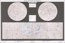
Double hemisphere map of the moon and chart showing landing/lunar surface exploration sites, published by NASA in 1970.
Color lithographed moon map with two stereographic projections of the North and South poles. The full lunar equatorial area is shown in Mercator projection between 45 degrees North and South latitude
LPC-1 is a combination of three 1:5M LMP-series charts (Lunar Earth Side, Far Side, Polar Charts).
Prepared By The Aeronautical Chart And Information Center, United States Air Force, Under The Direction Of The Department Of Defense.


![[ Exceptional original hand-color with highlights in gold ] Typus Aspectuum Oppositionum Et Coniunctionum Etz In Planetis](https://storage.googleapis.com/raremaps/img/small/81866.jpg)
![[ Walking on the Moon -- Apollo 15 Extra Vehicular Activity Atlas ] Hadley-Apennine Landing Site Apollo 15 - 1:12,500 and 1:25,000](https://storage.googleapis.com/raremaps/img/small/68099.jpg)