|
||

|

|
|

|
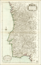
London-Published Spanish Language Map of Spain
Scarce map of Spain and Portugal, showing the Iberian Peninsula in full and colored according to regions.
The map is highly detailed, with a great number of cities and towns shown, relief shown pictorially, and names for rivers included. Regional names are shown, and detail extends into France, the Balearic Islands, and North Africa. The map includes a highly decorative cartouche, depicting two men, a sailing ship, and a strange crown. A distance key is shown in the lower left.
The mapmaker is unknown, but the text in the cartouche suggests it was published in London. The two copies listed in OCLC, at the Biblioteca Virtual del Ministerio de Defensa and the Institut Cartografic, both in Spain, suggest a publication date of 1750, but other sources suggest that this map was perhaps based on a William Faden map, which would date it to slightly later in the 18th century.
The map is probably by Pedro Gendron, see this map of the Americas for a comparison: www.raremaps.com/gallery/detail/8178
![[Palma, Tenerife, Gomera, Hierro] Isla Canarias 1a. Hoja](https://storage.googleapis.com/raremaps/img/small/79081.jpg)