|
||

|

|
|

|
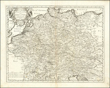
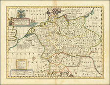
Decorative and highly detailed map of Germany, published in London by Emanuel Bowen in the mid-18th century for his A Complete System of Geography.
The map includes a high level of detail throughout the country, delimiting regional borders and naming rivers, cities, geographical features, and more. Detail on the map extends into Poland, Hungary, the Balkans, Italy, and France.
The map is highly decorative, in a style typical of Bowen. A humorous cartouche in the upper right shows a truly massive wine barrel, with a pastoral scene, and the map includes a compass rose in the upper left.
The map incorporates a number of sources, as indicated in the upper left, including Hubner, De L'Isle, Homman, Le Rouge, and others.
Emanuel Bowen (1694?-1767) was a British engraver and print seller. He was most well-known for his atlases and county maps. Although he died in poverty, he was widely acknowledged for his expertise and was appointed as mapmaker to both George II of England and Louis XV of France. His business was carried on by his son, Thomas Bowen. He also trained many apprentices, two of whom became prominent mapmakers, Thomas Kitchin and Thomas Jeffreys.
![[12 Folding Maps From the Library of the House of Bourbon-Orléans in Two Custom Red Morocco Boxes]](https://storage.googleapis.com/raremaps/img/small/99209.jpg)