|
||

|

|
|

|
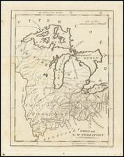
Competing Plans for the Layout of Downtown Detroit
Rare early plan of Detroit from a governmental publication that sought to resolve land issues in downtown Detroit. The map is based on an early 19th-century map produced by Philu Judd and J. O. Lewis that extended an early plan to the waterfront.
The 1805 Detroit fire necessitated the design of a new city plan, an effort that was spearheaded by Augustus Woodward. Inspired by the l'Enfant layout of Washington, D.C., Woodward planned a city with broad avenues and a central circus. While the Woodward design was accepted by the federal legislature (helped, no doubt, by Woodward's close friendship with Thomas Jefferson), later surveyors strayed from the original design. Further developments, such as the abandonment of Fort Shelby (formerly located near the present-day District Court) required redesigning of certain areas. Stakeholders disagreed vehemently regarding how these changes should be made. Plot holders disliked the original Woodward layout of the city because the angled streets led to less efficient use of their plots. Owners of riverfront property were opposed to any waterfront extension, as this was believed to devalue their property.
This controversy eventually reached the federal legislature, hence the inclusion of this map (along with two competing designs) in the American State Papers in 1830, and a later reissued in 1860 in a governmental publication following the continued debate over how Detroit should be built.
The Judd Map of Detroit
The Judd map, which the presented example is based on, was one of the competing plans proposed for the layout of Detroit southeast of Campus Mauritius. Judd's map was produced when Woodward's map required updating following the decommissioning of Fort Shelby (point E on the presented map). Judd's vision for the part of the city newly available to development was to continue Woodward's original radial design. However, a contrasting map by John Mullet preferred a more block-and-grid approach. While some compromises between the competing visions were attempted, it would be the Mullet map that most resembles Detroit south of Michigan Avenue today.
![[ The Old Northwest Territory ] Il Paese De Selvaggi Outagamiani, Mascoutensi Illinesi E parte Delle VI Naxioni](https://storage.googleapis.com/raremaps/img/small/75927.jpg)