


|
||

|

|
|

|
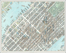
Detailed map of midtown Manhattan to the Flatiron Building, designed by Hermann Bollmann and providing one of the most detailed pictorial 20th-century views of the city.
The map is rendered as a bird’s-eye view in isometric perspective and focuses on the Midtown area between 13th and 69th streets. Bollman, a German artist, developed his own techniques for producing pictorial maps of cities which led to their high accuracy and beautiful nature.
The map was first issued for the 1964 New York World’s Fair and Bollman exhibited a massive version of his map on site. Smaller versions were issued in various formats including in a multilingual guidebook to the city, and a separate two-sided folding pocket map for visitors to the World’s Fair. This edition of the map was published in 1989 in Brunswick.