The item illustrated and described below is sold, but we
have another example in stock. To view the example which
is currently being offered for sale, click the
"View Details" button below.
![[ Carolinas & Georgia ] Carte De La Caroline Et Georgie . . . By A. Krevelt](https://storage.googleapis.com/raremaps/img/small/99744.jpg)


|
||

|

|
|

|
Stock# 79739
Description
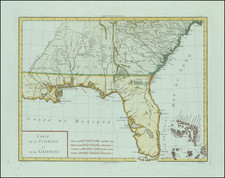
Detailed map of the region from just north of Albemarle to Jekil Isle, extending inland to the Appalachians and showing part of Eastern Tennessee.
Shows extensive river system, mountains, islands and some early settlements on both sides of the mountains.
A nice early regional map. From the Dutch edition of Bellin's Histoire General des Voyages.
![(Carolinas) Virginiae Partis australis, et Floridae partis orientalis, interjacentiumqus regionum Nova Descriptio [A New Description of the Southern Part of Virginia and the Eastern Part of Florida, and the Intervening Regions.]](https://storage.googleapis.com/raremaps/img/small/94131.jpg)
![( South Carolina Manuscript Plat Map ) [Land grant document signed by Revolutionary War hero William Moultrie with plat map signed by surveyor general Peter Bremar and deputy surveyor David Reynolds] State of South-Carolina. To all to whom these presents shall come, greeting... by these Presents do grant unto the said Harmon Dees ... a Plantation or Tract of Land, containing Four Hundred Acres situate in the District of Camden on Polly Bridge Swamp waters of Black River](https://storage.googleapis.com/raremaps/img/small/84439.jpg)