
The item illustrated and described below is sold, but we
have another example in stock. To view the example which
is currently being offered for sale, click the
"View Details" button below.


|
||

|

|
|

|
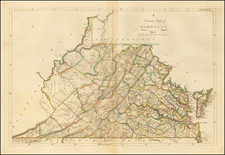
Stock# 79717
Description
Nice example of the 1814 edition of Carey's map of Virginia, one of the best large format maps of the state to appear in a Commercial Atlas.
The map is attractively hand colored by counties and shows, towns, roads, mountains, rivers, lakes, islands, bays and a host of other early important details.
Carey's General Atlas was first published in 1796, with periodic revisions up to 1818. It was the first American Atlas to be offered for sale with hand coloring on the maps.
![[Jefferson's Notes on the State of Virginia] Observations sur la Virginie [with the map:] A Map of the country between Albemarle Sound, and Lake Erie, comprehending the whole of Virginia, Maryland, Delaware, and Pensylvania, with parts of several other of the United States of America. Engraved for the Notes on Virginia.](https://storage.googleapis.com/raremaps/img/small/51828.jpg)
![[ 20 Historical Border Survey Maps Tracking The History of Pennsylvania's Borders ]](https://storage.googleapis.com/raremaps/img/small/96836.jpg)