|
||

|

|
|

|
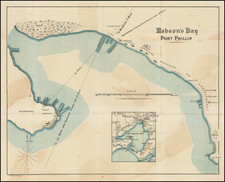
Detailed Chart of Shark Bay, from Freycinet’s Second Expedition to Australia
Fine example of Louis-Claude de Freycinet’s chart of Shark Bay, known in French as the Baie des Cheins-Marins, in Western Australia. The chart appeared in the influential atlas volume that accompanied the official account of Freycinet’s voyage in L’Uranie (1817-1820).
This was not Freycinet’s first visit to the bay. He had also surveyed it as a member of the Baudin expedition (1800-1804). The soundings from this first voyage are included on this chart, while the more recent soundings are marked with the track of L’Uranie and its smaller boat. The coastline that was sighted from L’Uranie is drawn with solid lines, while that which was only seen at a great distance, or which was taken from Freycinet’s earlier charts, are drawn with dashed lines. The anchorage of L’Uranie is indicated with an anchor symbol, and the observatory the crew erected near Cap Lesueur is also shown.
Many of the place names stem from Freycinet’s first experiences in Australian waters. The initial observations were made by Pierre Faure, whose name is on a small island in the inner reaches of the bay. Both of the larger vessels used in the Baudin expedition, the Géographe and the Naturaliste, are used to denote passages nearby. The two branches of the bay are named for Jacques Felix Emmanuel Hamelin, Baudin’s second in command, and for Henri Freycinet. Louis-Henri was Louis-Claude Freycinet’s brother and he was also a member of the Baudin expedition.
There are new features here too. The chart references Freycinet's devotion to his wife Rose, as “Cap Rose” is on the Péron Peninsula, opposite Île Faure. Rose accompanied Freycinet on L’Uranie, which was unusual for the time.
Nor was Freycinet the first European to probe these waters; indeed, Shark Bay was one of the most important early encounter points for both the Dutch and the English. The first Dutch voyage in Western Australia was in this area in 1616.
The first English navigator to spend significant time in the area, William Dampier, named Shark Bay during his voyage in 1699. He also called the aboriginal peoples he encountered on that voyage the most miserable people in the world, a pejorative description that unfortunately continued to circulate for decades thanks to the popularity of Dampier’s voyage accounts.
Hartog’s pewter dish and Dutch exploration of Western Australia
The coastlines of Western Australia are based on early Dutch discoveries, including ships that were stranded, shipwrecked, and blown off course. The most noteworthy Dutch discovery is that of the Eendracht, which was blown off course en route to the East Indies in 1616. It was commanded by Dirk Hartog, commemorated with the Île Dirck-Hartichs as written on this chart.
Hartog’s landing was the first recorded European landing on the western coast of Australia and the crew commemorated their discovery by erecting a post with a pewter dish inscribed with their ship’s information—the earliest physical record that historians have of any European landing in Australia. Hartog returned to tell of his feat to his employer, the Dutch East India Company (VOC), and the feature entered maps as early as 1623.
The dish marked the place of Hartog’s landing until 1697, when it was found by another Dutch crew, led by Willem de Vlamingh. Vlamingh took the original and replaced it with a copy that also recorded his visit. The original dish was placed in the VOC’s archives. Vlamingh’s dish stayed in place and was found, fallen over, by Hamelin, whose name also graces this chart, in 1801. Hamelin commanded the Naturaliste on the Baudin expedition, the same expedition of which Freycinet was a part and on which he made his initial survey. It was Freycinet who named Cape de l’Inscription, at the northern end of the island, which is where the posts and dishes were erected.
Hamelin reattached the dish to its post, but it was taken down by none other than Louis de Freycinet when he commanded his own expedition to the coast in 1818. Freycinet had disagreed with Hamelin that the plate should be left in place; Hamelin thought it sacrilege to remove the relic while Freycinet thought it sacrilege to continue to expose such a historical item to the elements. Freycinet took it back to France with him, where it was lost. Only in 1940 did the dish reappear, in a store cupboard in the French Academy. It was presented as a gift to Australia in 1947. Today, it is on display at the Western Australia Museum. The original Hartog plate is at the Rijksmuseum in Amsterdam.
Dampier’s voyage and Shark Bay
William Dampier, a sometime pirate and superb navigator, circumnavigated the world three times. In 1697, after the first circumnavigation that had taken over a decade to complete, Dampier published a book of his travels, A New Voyage Round the World, complete with extensive natural historical descriptions. His publication was so popular that even the Admiralty was impressed.
The Admiralty granted Dampier a ship, the Roebuck, and instructions to seek the east coast of New Holland. He set out in January 1699, rounded the Cape of Good Hope and rode the winds to the west coast of New Holland. Dampier and his crew crossed between Dirk Hartog Island and the mainland in August, 1699. He anchored in what he called Shark’s Bay, seen here. The crew landed on the mainland and recorded some of the first written accounts of Australian plant and animal life.
Dampier continued northeast round the continent and charted the passage between the islands of the Bismarck Archipelago, henceforth called Dampier’s Strait on maps. However, the ship was too damaged to continue down the east coast of Australia. Instead, Dampier tried for England but had to run his ship aground on Ascension Island. After five weeks marooned there, the crew was picked up by an East Indiaman and they returned to England in August 1701. The buccaneer was court martialed upon his arrival for maltreatment of his lieutenant, whom he had left in Brazil. Dampier published his journals about this voyage in 1703, and they popularized the geography and natural history of Australia.
Louis-Claude Freycinet, his expeditions, and his atlases: The Baudin expedition
This chart featured in the atlas volume that was part of the voyage account of L’Uranie. It builds on a similar chart that Freycinet included in his account of the Baudin expedition.
When Nicolas Baudin left Le Havre in the Geographe and the Naturaliste in October 1800, he was embarking on a voyage meant to survey the shores of Australia. At this time, the British had established their presence in eastern Australia, but the western and southern portions of the continent remained unexplored and not necessarily claimed by the British. In other words, although ostensibly a scientific expedition, the French were also open to possible overseas expansion if the opportunity arose.
In the Naturaliste, commanded by the aforementioned Captain Hamelin, was Louis Freycinet, then only 21 years old. He had joined the French Navy in 1793 and was accompanied on this voyage by his brother, Louis-Henri, who would go on to become an admiral.
Initially the ships, sometimes separated, made their way north up the western coast of Australia from Cape Leeuwin to Timor. They then went south again, but were separated a second time. Baudin and the Geographe made for Van Diemen’s Land and then returned toward the west. En route, they encountered British naval officer Matthew Flinders in the Investigator. Flinders, on his third Australian surveying mission, was heading to Sydney, from where he would begin a clockwise circumnavigation of the Australian continent, the first such voyage to ever do so. Flinders named the place where he and Baudin met Encounter Bay.
Baudin and Hamelin were reunited in Sydney, where both ships had come to recuperate in late 1801. While there, Baudin purchased a 29-foot vessel. He named it Casuarina and placed Freycinet, who had proved himself an adroit hydrographer under Hamelin, in command. With his new charge, Freycinet was to perform inshore surveys.
During the course of 1802, the Geographe and the Casuarina surveyed the southern coast of Australia (the Naturaliste had been sent back to France). They then sailed round the west coast to Timor, then back to Mauritius, where Baudin died. It was also where the Casuarina’s career ended, as the ship was abandoned in favor of consolidating the crews on the Geographe. The ship returned home on March 25, 1804.
Back in France, and with Baudin dead, Freycinet and the voyage’s naturalist, Peron (whose name is also a toponym here), were left to prepare the account and charts of the voyage. Flinders by this time was imprisoned in Mauritius, so the French charts were the first on the market. Baudin was not generally well liked by his fellow sailors, a fact borne out by the limited reference made to him or his discoveries in the narrative and maps of the voyage. The French maps also do not recognize the prior claims of first discovery by men like Flinders, in an attempt to give France more prominence. However, Freycinet did likely have access to copies of Flinders’ documents seized when he was imprisoned, improving the detail of his charts.
The official account appeared over ten years and in four volumes. The first narrative of the voyage, primarily by Peron, was published in 1807. The second narrative volume was published in 1816 and was written primarily by Freycinet; Peron had died in 1810. The first part of the atlas, which contained 40 engraved plates, two of them folding, appeared in 1807. The second part was published in 1811 with 14 engraved charts and maps, two of them double-page layouts. These double-page charts include a map of the Australian continent, the first map to show the continent in its entirety and made partially from Flinders’ papers. A hydrographic atlas followed in 1812 (distributed in 1814) and is the rarest of the Baudin expedition publications. It contained 32 engraved charts, 25 of them double-page. An accompanying text volume was published in 1815, also by Freycinet.
Louis-Claude Freycinet, his expeditions, and his atlases: L’Uranie expedition
The publications stemming from the Baudin expedition would have been enough to secure the fame of Louis Freycinet. However, he is perhaps best known today for his second voyage to the Pacific, one he commanded in L’Uranie. The voyage was meant to proclaim post-Napoleonic France’s scientific credentials and Freycinet was to make meteorological, geodetic, magnetic, ethnographic, geographical, and natural historical observations.
The ship left Toulon in mid-September 1817. Unknown to many of the crew, Rose Freycinet, Louis-Claude’s wife, had come on board; she would write a separate account of the voyage. L’Uranie sailed via the Cape of Good Hope to Mauritius, where brother Louis-Henri was governor. Then, the ship headed to Shark Bay, reaching it in September 1818, as shown on this chart. There, Freycinet’s crew set up an observatory and re-surveyed the area. As previously mentioned, he also retrieved the plate left by de Vlamingh.
The ship then sailed to Timor, followed by the Moluccas, the Carolines, the Marianas, and Hawai’i. The crew came to Port Jackson in late 1819, where they spent Christmas. In the new year, they sailed for the tempestuous waters of Cape Horn. On February 14, L’Uranie foundered in the Falkland Islands. Miraculously, the huge store of scientific samples and notes, as well as de Vlamingh’s plate, were saved, although 2,500 of the 4,175 plant samples were lost. The crew were saved by a sealing vessel and then a ship carrying Chilean rebels; Freycinet bought the latter and renamed it La Physicienne. Rose and Louis-Claude made it back to France in November 1820.
Freycinet set to work on the official voyage account soon after his return; the project would consume the rest of his life. His findings were published in nine quarto volumes, with four additional volumes of plates and maps, between 1824 and 1844. Overall, there are 355 engraved plates, maps, and plans; 120 of these were in color. This map featured in the Navigation et Hydrographie volume, published in 1826.
The voyage secured Freycinet a place in the Academie des Sciences. He also went on to help found the Paris Geographical Society, the first such group of its kind. Louis Freycinet died in 1841.
Rarity
The charts of the Navigation et Hydrographie volume are rarely seen on the market. This is the first time we have offered this chart in over twenty-five years of trading.
Louis Claude Desaulses de Freycinet (1779-1841) was a French hydrographer and explorer. He joined the French Navy in 1793. In October 1800, at the age of 21, Freycinet set off in the Naturaliste, part of an exploratory expedition to chart Australia. He was accompanied on this voyage by his brother, Louis-Henri, who would go on to become an admiral.
In Sydney, the leader of the expedition, Nicholas Baudin, purchased a 29-foot vessel. He named it Casuarina and placed Freycinet, who had proven himself an adroit hydrographer, in command. With his new charge, Freycinet was to perform inshore surveys. During the course of 1802, the Casuarina charted large portion of the southern coast of Australia.
Freycinet returned to France in 1804. Since Baudin had died in Mauritius, the naturalist Francois Peron and Freycinet were directed to prepare for publication the official account of the voyage, with an accompanying atlas. The official account appeared over ten years and in four volumes. The first narrative of the voyage, primarily by Peron, was published in 1807. The second narrative volume was published in 1816 and was written primarily by Freycinet. Peron had died in 1810. The first part of the Atlas, which contained 40 engraved plates, two of them folding, appeared in 1807. The second atlas, was published in 1811 with 14 engraved charts, two of them double-page. These double-page maps include a map of the Australian continent, the first map to show the continent in its entirety and made partially from Matthew Flinders’ papers.
His publications stemming from the Baudin expedition would have been enough to secure the fame of Louis Freycinet. However, he is perhaps best known today for his second voyage to the Pacific, one he commanded in the Uranie. From 1817 to 1820, Freycinet cruised the Pacific performing experiments and, of course, making detailed charts. He was accompanied by his wife Rose.
Although the Uranie was wrecked in the Falklands on the return journey, the natural historical specimens and geographical notes were saved. They were published in 13 volumes with 4 additional volumes of plates and maps between 1824 and 1844.
The voyage secured Freycinet a place in the Academie des Sciences. He also went on to help found the Paris Geographical Society, the first such group of its kind. Louis Freycinet died in 1841.
![Western Australia containing the Settlements of Swan River and King George's Sound… [with ] Van Diemen Island](https://storage.googleapis.com/raremaps/img/small/99485.jpg)