|
||

|

|
|

|
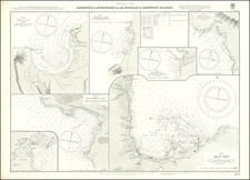
Kailua Bay, Hawaii -- Site of the Death of Captain James Cook
Exceedingly rare plan of Kailua Bay on the Island of Hawaii, the first ever printed plan of the Bay.
Often confused with Kealakekua Bay, this is actually the first map ever of Kailua Bay, on the Big Island. Kayakakoua was the ancient Hawaiian name for Kailua Beach, and the map was further confusing in that Duperry made a serious mistake in latitude on the map. Otherwise the accuracy of this map is verified quite nicely by modern maps of Kailua Bay.
The map is based upon the surveys taken by Louis-Isidore Duperrey, who participated in the Louis de Freycinet's second circumnavigation. In 1817, Freycinet set sail on his second major voyage on the Uranie, in which Louis Isidore Duperrey, Jacques Arago, Adrien Taunay the Younger, and others, went to Rio de Janeiro to take a series of pendulum measurements. As well, was a larger scheme for obtaining observations, not only in geography and ethnology, but in astronomy, terrestrial magnetism, and meteorology, and for the collection of specimens in natural history. The voyage lasted for 3 years, visiting Australia, the Mariana Islands, Hawaiian Islands, and other Pacific islands, South America, and other places, and, notwithstanding the loss of the Uranie on the Falkland Islands during the return voyage, returned to France with fine collections in all departments of natural history, and with voluminous notes and drawings of the countries visited.
The results of this voyage were published under Freycinet's supervision in monumental work of 17 volumes, with the title of Voyage autour du monde fait par ordre du Roi sur les corvettes de S. M. l'Uranie et la Physicienne, pendant les années 1817, 1818, 1819 et 1820, consisting of 13 quarto volumes and 4 folio volumes of plates and maps.
The map was first issued in the atlas to accompany Freycient's voyage and was also issued as a separate sheet, with a price. The title of the separate map includes the parenthetical statement as follows: Plan De La Rade De Kayakakoua (ou Kairua du No. 1151 et Tyetatooa du No. 573) sur l'ile Owhyhi Leve et dresse P ar Mr. L.I. Duperrey, Officer de Marine, Embarque sur la Corvette du Roi l'Uranie. Auot 1819