|
||

|

|
|

|
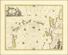
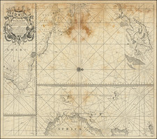
Rare Map of the Gulf of Mexico from a Contemporary History of the American Revolution
Fine original antique map of the Gulf of Mexico, based on charts issued by Nicolas Bellin and the Depot de la Marine. The map shows the Caribbean, the Bahamas, the Yucatan, Central America, Cartagena, and Venezuela.
The map appeared in Le Boucher's Histoire de la Derniere Guerre, entre La Grande-Bretagne, et les Etas-Unis de l'Amerique. This history of the American Revolution was published in Paris in 1787 and provided a contemporary look at the style in which the war was fought and its effects.
The map shows Florida as a peninsula, postdating Florida as an archipelago myth introduced by Thomas Nairne.
This is the first time we have handled the map. The map is very scarce on the market.
Jacques-Nicolas Bellin (1703-1772) was among the most important mapmakers of the eighteenth century. In 1721, at only the age of 18, he was appointed Hydrographer to the French Navy. In August 1741, he became the first Ingénieur de la Marine of the Dépôt des cartes et plans de la Marine (the French Hydrographic Office) and was named Official Hydrographer of the French King.
During his term as Official Hydrographer, the Dépôt was the one of the most active centers for the production of sea charts and maps in Europe. Their output included a folio-format sea atlas of France, the Neptune Francois. He also produced a number of sea atlases of the world, including the Atlas Maritime and the Hydrographie Francaise. These gained fame and distinction all over Europe and were republished throughout the eighteenth and even in the nineteenth century.
Bellin also produced smaller format maps such as the 1764 Petit Atlas Maritime, containing 580 finely-detailed charts. He also contributed a number of maps for the 15-volume Histoire Generale des Voyages of Antoine François Prévost.
Bellin set a very high standard of workmanship and accuracy, cementing France's leading role in European cartography and geography during this period. Many of his maps were copied by other mapmakers across the continent.