This item has been sold, but you can enter your email address to be notified if another example becomes available.


|
||

|

|
|

|
Stock# 79662
Description
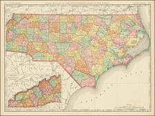
Scarce map of North Carolina and South Carolina, from Morse's Universal Geography.
The map is one of the earlist obtainable American printed maps of the States of North Carolina and South Carolina.
Includes counties, towns, rivers, roads, islands, harbors, points, etc.
Reference
Wheat & Brun 585.