


|
||

|

|
|

|
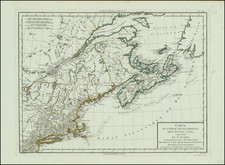
One of the earliest maps to illustrate dramatic shift from Dutch to English dominance in the Northeast in the latter part of the 17th Century.One of the first printed maps to use the term New York for both both Manhattan (formerly New Amsterdam) and New New York State, as well as one of the earliest appearances of New Iarsey (Jersey). One of only a small group of English maps of New England, prior to 1700. Based on Jansson's map of 1651, it illustrates the territories acquired by the British with the capture of New Amsterdam in 1664, which radically adjusted the landscape North American politics. While the map's geographical features are largely drawn from Jansson, the map's nomenclature is substantially anglicized, including the first appearance of name Boston (ommitted from the Jansson maps) and the use of the names New York and Cape Cod. The map is richly embellished with various animals in the interiior of the map, two compass roses, two cartouches and a coat of arms. A nice example in full color, with nice wide margins. From the 1676 edition of Speed's Prospect of the Most Famous Parts of the World, bearing the imprint of Bassett & Chiswell. Tooley #23; McCorkle 676.
John Speed (1551 or '52 - 28 July 1629) was the best known English mapmaker of the Stuart period. Speed came to mapmaking late in life, producing his first maps in the 1590s and entering the trade in earnest when he was almost 60 years old.
John Speed's fame, which continues to this day, lies with two atlases, The Theatre of the Empire of Great Britaine (first published 1612), and the Prospect of the Most Famous Parts of the World (1627). While The Theatre ... started as solely a county atlas, it grew into an impressive world atlas with the inclusion of the Prospect in 1627. The plates for the atlas passed through many hands in the 17th century, and the book finally reached its apotheosis in 1676 when it was published by Thomas Bassett and Richard Chiswell, with a number of important maps added for the first time.
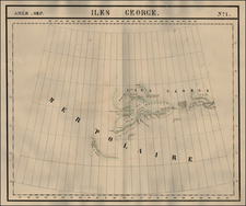
![[MacKenzie River, Yukon Territory and Northwest Territory] Amer. Sep. No. 15. Grand Lac De L'Esclave](https://storage.googleapis.com/raremaps/img/small/19469.jpg)
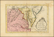
![[ Queen Anne's War - Failed Attack on French Canada -- Petition to Queen Anne from the Colony of New York seeking reimbursement for a failed conquest of New France during Queen Anne's War ] To the Queens most Excellent Majesty . . . 1709](https://storage.googleapis.com/raremaps/img/small/85409.jpg)