The item illustrated and described below is sold, but we
have another example in stock. To view the example which
is currently being offered for sale, click the
"View Details" button below.


|
||

|

|
|

|
Stock# 79640
Description
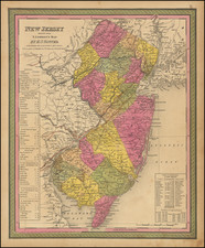
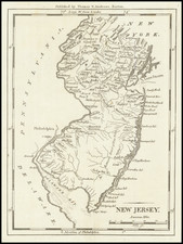
One of the Earliest American-Printed Maps of New Jersey
Detailed map of New Jersey, from Morse's Universal Geography. This fantastic depiction of the state shows rivers, a number of towns, and the start of the Appalachians. Part of New York, Long Island, and Staten Island are visible.
The map was engraved by Samuel Hill, a famous early American engraver who collaborated with Morse on a number of cartographic projects. This copperplate engraving first appeared in Morses' The American Universal Geography, one of the earliest American-published atlases.
Condition Description
Original hand-color, recently retocuhed.
Reference
Wheat & Brun 417.